Zlătunoaia geodata
Zlătunoaia (Botoşani) is a populated place; located in Romania in Europe/Bucharest (GMT+3) time zone. With population of 2,386 people, there are 2250 cities with bigger population in this country. Compared to other cities in Romania, 94.1% of cities are located further ↓South; 83% of cities are located further ←West and 59.2% of cities have higher elevation than Zlătunoaia. Note1


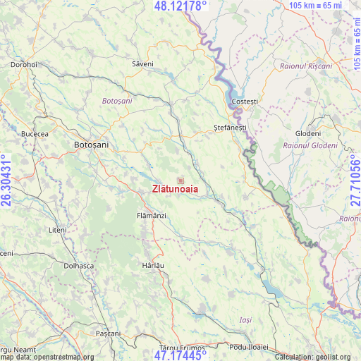
Zlătunoaia GPS coordinates[2]
47° 39' 0.936" North, 27° 0' 26.748" East
| Map corner | latitude | longitude |
|---|---|---|
| Upper-left | 48.12178°, | 26.30431° |
| Center: | 47.65026°, | 27.00743° |
| Lower-right: | 47.17445°, | 27.71056° |
| Map W x H: | 105.3×105.3 km | = 65.4×65.4mi |
| max Lat: | 48.23793° ⇑5.9% North |
| Zlătunoaia: | 47.65026° |
| min Lat: | ⇓94.1% South 43.65638° |
| min Long | Zlătunoaia | max Long |
| 20.31667° | 27.00743° | 29.65403° |
| W 83%⇐ | ⇒17% E |
Elevation
Elevation of Zlătunoaia is 169 m = 554 ft, and this is 85.9 m = 282 ft below average elevation for this country.
| Max E: |
1278 m = 4193 ft | 59.2% |
| Avg. | 254.9 m = 836 ft | |
| Zlătunoaia | 169 m = 554 ft | |
Min E: |
-2 m = -7 ft | 40.8% |
See also: Romania elevation on elevation.city.
Geographical zone
Zlătunoaia is located in North temperate zone (between Tropic of Cancer and the Arctic Circle). Distance of this North polar circle is 2103 km =1306.7 mi to North.| Distance of | km | miles | from Zlătunoaia |
|---|---|---|---|
| North Pole | 4708.8 | 2925.9 | to North |
| Arctic Circle | 2103 | 1306.7 | to North |
| Tropic Cancer | 2692.3 | 1672.9 | to South |
| Equator | 5298.2 | 3292.1 | to South |


Nearby cities:
15 places around Zlătunoaia: (largest is in red/bold)
• Albeşti
7.1 km =4.4 mi,  38°
38°
• Buimăceni
6.7 km =4.2 mi,  68°
68°
• Cerbu
9.8 km =6.1 mi,  248°
248°
• Cerchejeni
10.4 km =6.5 mi,  296°
296°
• Cernești
8 km =5 mi,  123°
123°
• Chițoveni
10.8 km =6.7 mi,  211°
211°
• Coștiugeni
4.8 km =3 mi, 35°
• Dracșani
6.2 km =3.9 mi, 248°
• Ionășeni
9 km =5.6 mi,  353°
353°
• Iurești
6 km =3.7 mi,  108°
108°
• Jijia
6.8 km =4.2 mi,  91°
91°
• Lunca
4.1 km =2.5 mi, 205°
• Stroiești
5.4 km =3.4 mi,  215°
215°
• Sulița
6.8 km =4.2 mi,  269°
269°
• Todireni
9 km =5.6 mi, 114°
Sources, notices
• [Note1] Compared only with cities in Romania existing in our database
• [Src1] Map data: © OpenStreetMap contributors (CC-BY-SA)
• [Src2] Other city data from geonames.org with taken over terms of usage.
• [Src3] Geographical zone / Annual Mean Temperature by Robert A. Rohde @ Wikipedia
