Zimnicea geodata
Zimnicea (Teleorman) is a seat of a second-order administrative division; located in Romania in Europe/Bucharest (GMT+3) time zone. With population of 15,228 people, there are 131 cities with bigger population in this country. Compared to other cities in Romania, 100% of cities are located further ↑North; 52.1% of cities are located further ←West and 96.6% of cities have higher elevation than Zimnicea. Note1


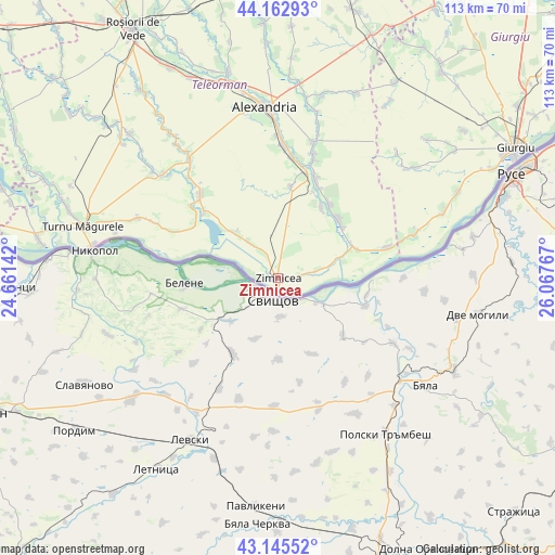
Zimnicea GPS coordinates[2]
43° 39' 22.968" North, 25° 21' 52.344" East
| Map corner | latitude | longitude |
|---|---|---|
| Upper-left | 44.16293°, | 24.66142° |
| Center: | 43.65638°, | 25.36454° |
| Lower-right: | 43.14552°, | 26.06767° |
| Map W x H: | 113.1×113.1 km | = 70.3×70.3mi |
| max Lat: | 48.23793° ⇑100% North |
| Zimnicea: | 43.65638° |
| min Lat: | ⇓0% South 43.65638° |
| min Long | Zimnicea | max Long |
| 20.31667° | 25.36454° | 29.65403° |
| W 52.1%⇐ | ⇒47.9% E |
Elevation
Elevation of Zimnicea is 26 m = 85 ft, and this is 228.9 m = 751 ft below average elevation for this country.
| Max E: |
1278 m = 4193 ft | 96.6% |
| Avg. | 254.9 m = 836 ft | |
| Zimnicea | 26 m = 85 ft | |
Min E: |
-2 m = -7 ft | 3.4% |
See also: Romania elevation on elevation.city.
Geographical zone
Zimnicea is located in North temperate zone (between Tropic of Cancer and the Arctic Circle). Distance of this Northern Tropic circle is 2248.2 km =1397 mi to South.| Distance of | km | miles | from Zimnicea |
|---|---|---|---|
| North Pole | 5152.9 | 3201.9 | to North |
| Arctic Circle | 2547 | 1582.6 | to North |
| Tropic Cancer | 2248.2 | 1397 | to South |
| Equator | 4854.1 | 3016.2 | to South |


Nearby cities:
15 places around Zimnicea: (largest is in red/bold)
• Bragadiru
17.3 km =10.7 mi,  44°
44°
• Bujoru
17.6 km =10.9 mi,  67°
67°
• Cervenia
21.3 km =13.2 mi,  22°
22°
• Conţeşti
18.6 km =11.6 mi,  30°
30°
• Frumoasa
18 km =11.2 mi, 27°
• Fântânele
9.2 km =5.7 mi,  321°
321°
• Izvoarele
17.9 km =11.1 mi,  4°
4°
• Năsturelu
8.3 km =5.2 mi,  82°
82°
• Păuleasca
18.9 km =11.7 mi, 23°
• Smârdioasa
22.2 km =13.8 mi,  14°
14°
• Suhaia
12.6 km =7.8 mi,  312°
312°
• Viişoara
21.3 km =13.2 mi, 311°
• Vânători
20 km =12.4 mi,  302°
302°
• Zimnicele
3.9 km =2.4 mi, 82°
• Șoimu
20.6 km =12.8 mi, 18°
Sources, notices
• [Note1] Compared only with cities in Romania existing in our database
• [Src1] Map data: © OpenStreetMap contributors (CC-BY-SA)
• [Src2] Other city data from geonames.org with taken over terms of usage.
• [Src3] Geographical zone / Annual Mean Temperature by Robert A. Rohde @ Wikipedia
