Fântânele geodata
Fântânele (Teleorman) is a seat of a second-order administrative division; located in Romania in Europe/Bucharest (GMT+3) time zone. With population of 2,328 people, there are 2295 cities with bigger population in this country. Compared to other cities in Romania, 99.9% of cities are located further ↑North; 51.2% of cities are located further ←West and 83.1% of cities have higher elevation than Fântânele. Note1


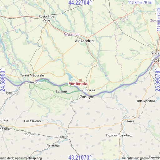
Fântânele GPS coordinates[2]
43° 43' 15.744" North, 25° 17' 33.54" East
| Map corner | latitude | longitude |
|---|---|---|
| Upper-left | 44.22704°, | 24.58953° |
| Center: | 43.72104°, | 25.29265° |
| Lower-right: | 43.21073°, | 25.99578° |
| Map W x H: | 113×113 km | = 70.2×70.2mi |
| max Lat: | 48.23793° ⇑99.9% North |
| Fântânele: | 43.72104° |
| min Lat: | ⇓0.1% South 43.65638° |
| min Long | Fântânele | max Long |
| 20.31667° | 25.29265° | 29.65403° |
| W 51.2%⇐ | ⇒48.8% E |
Elevation
Elevation of Fântânele is 84 m = 276 ft, and this is 170.9 m = 561 ft below average elevation for this country.
| Max E: |
1278 m = 4193 ft | 83.1% |
| Avg. | 254.9 m = 836 ft | |
| Fântânele | 84 m = 276 ft | |
Min E: |
-2 m = -7 ft | 16.9% |
See also: Romania elevation on elevation.city.
Geographical zone
Fântânele is located in North temperate zone (between Tropic of Cancer and the Arctic Circle). Distance of this Northern Tropic circle is 2255.4 km =1401.4 mi to South.| Distance of | km | miles | from Fântânele |
|---|---|---|---|
| North Pole | 5145.7 | 3197.4 | to North |
| Arctic Circle | 2539.9 | 1578.2 | to North |
| Tropic Cancer | 2255.4 | 1401.4 | to South |
| Equator | 4861.3 | 3020.7 | to South |


Nearby cities:
15 places around Fântânele: (largest is in red/bold)
• Conţeşti
17.7 km =11 mi,  60°
60°
• Frumoasa
16.5 km =10.3 mi, 57°
• Izvoarele
12.9 km =8 mi,  34°
34°
• Lisa
15.5 km =9.6 mi,  304°
304°
• Năsturelu
15.2 km =9.4 mi,  113°
113°
• Năvodari
16.1 km =10 mi,  278°
278°
• Piatra
14.7 km =9.1 mi,  316°
316°
• Păuleasca
16.7 km =10.4 mi,  52°
52°
• Smârdioasa
18.3 km =11.4 mi,  38°
38°
• Suhaia
3.7 km =2.3 mi,  291°
291°
• Viişoara
12.3 km =7.6 mi, 304°
• Vânători
11.7 km =7.3 mi, 287°
• Zimnicea
9.2 km =5.7 mi,  141°
141°
• Zimnicele
11.7 km =7.3 mi,  124°
124°
• Șoimu
17.4 km =10.8 mi, 44°
Sources, notices
• [Note1] Compared only with cities in Romania existing in our database
• [Src1] Map data: © OpenStreetMap contributors (CC-BY-SA)
• [Src2] Other city data from geonames.org with taken over terms of usage.
• [Src3] Geographical zone / Annual Mean Temperature by Robert A. Rohde @ Wikipedia
