Zăvoaia geodata
Zăvoaia (Brăila) is a seat of a second-order administrative division; located in Romania in Europe/Bucharest (GMT+3) time zone. With population of 3,482 people, there are 1437 cities with bigger population in this country. Compared to other cities in Romania, 71.7% of cities are located further ↑North; 90.7% of cities are located further ←West and 95% of cities have higher elevation than Zăvoaia. Note1


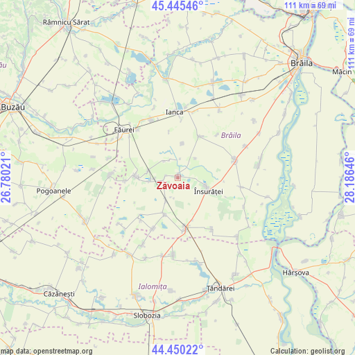
Zăvoaia GPS coordinates[2]
44° 57' 0" North, 27° 28' 59.988" East
| Map corner | latitude | longitude |
|---|---|---|
| Upper-left | 45.44546°, | 26.78021° |
| Center: | 44.95°, | 27.48333° |
| Lower-right: | 44.45022°, | 28.18646° |
| Map W x H: | 110.7×110.7 km | = 68.8×68.8mi |
| max Lat: | 48.23793° ⇑71.7% North |
| Zăvoaia: | 44.95° |
| min Lat: | ⇓28.3% South 43.65638° |
| min Long | Zăvoaia | max Long |
| 20.31667° | 27.48333° | 29.65403° |
| W 90.7%⇐ | ⇒9.3% E |
Elevation
Elevation of Zăvoaia is 35 m = 115 ft, and this is 219.9 m = 721 ft below average elevation for this country.
| Max E: |
1278 m = 4193 ft | 95% |
| Avg. | 254.9 m = 836 ft | |
| Zăvoaia | 35 m = 115 ft | |
Min E: |
-2 m = -7 ft | 5% |
See also: Romania elevation on elevation.city.
Geographical zone
Zăvoaia is located in North temperate zone (between Tropic of Cancer and the Arctic Circle). Distance of this Northern Tropic circle is 2392.1 km =1486.4 mi to South.| Distance of | km | miles | from Zăvoaia |
|---|---|---|---|
| North Pole | 5009.1 | 3112.5 | to North |
| Arctic Circle | 2403.2 | 1493.3 | to North |
| Tropic Cancer | 2392.1 | 1486.4 | to South |
| Equator | 4998 | 3105.6 | to South |


Nearby cities:
15 places around Zăvoaia: (largest is in red/bold)
• Batogu
6.7 km =4.2 mi,  321°
321°
• Bordei Verde
16.2 km =10.1 mi,  23°
23°
• Bărăganul
16.9 km =10.5 mi,  171°
171°
• Cireşu
10.5 km =6.5 mi,  270°
270°
• Colțea
16.6 km =10.3 mi,  225°
225°
• Dudescu
4 km =2.5 mi, 271°
• Dudeşti
6.8 km =4.2 mi,  215°
215°
• Jugureanu
16.1 km =10 mi, 267°
• Lișcoteanca
8.2 km =5.1 mi,  42°
42°
• Scărlătești
7.1 km =4.4 mi, 268°
• Târlele Filiu
10.8 km =6.7 mi,  6°
6°
• Tătaru
12.3 km =7.6 mi,  198°
198°
• Ulmu
13.1 km =8.1 mi, 270°
• Vultureni
9.4 km =5.8 mi,  263°
263°
• Însurăţei
9.9 km =6.2 mi,  111°
111°
Sources, notices
• [Note1] Compared only with cities in Romania existing in our database
• [Src1] Map data: © OpenStreetMap contributors (CC-BY-SA)
• [Src2] Other city data from geonames.org with taken over terms of usage.
• [Src3] Geographical zone / Annual Mean Temperature by Robert A. Rohde @ Wikipedia
