Zam geodata
Zam (Hunedoara) is a seat of a second-order administrative division; located in Romania in Europe/Bucharest (GMT+3) time zone. With population of 2,121 people, there are 2496 cities with bigger population in this country. Compared to other cities in Romania, 55% of cities are located further ↓South; 90.2% of cities are located further →East and 55% of cities have lower elevation than Zam. Note1


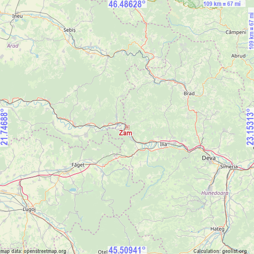
Zam GPS coordinates[2]
46° 0' 0" North, 22° 27' 0" East
| Map corner | latitude | longitude |
|---|---|---|
| Upper-left | 46.48628°, | 21.74688° |
| Center: | 46°, | 22.45° |
| Lower-right: | 45.50941°, | 23.15313° |
| Map W x H: | 108.6×108.6 km | = 67.5×67.5mi |
| max Lat: | 48.23793° ⇑45% North |
| Zam: | 46° |
| min Lat: | ⇓55% South 43.65638° |
| min Long | Zam | max Long |
| 20.31667° | 22.45° | 29.65403° |
| W 9.8%⇐ | ⇒90.2% E |
Elevation
Elevation of Zam is 238 m = 781 ft, and this is 16.9 m = 55 ft below average elevation for this country.
| Max E: |
1278 m = 4193 ft | 45% |
| Avg. | 254.9 m = 836 ft | |
| Zam | 238 m = 781 ft | |
Min E: |
-2 m = -7 ft | 55% |
See also: Romania elevation on elevation.city.
Geographical zone
Zam is located in North temperate zone (between Tropic of Cancer and the Arctic Circle). Distance of this North polar circle is 2286.5 km =1420.8 mi to North.| Distance of | km | miles | from Zam |
|---|---|---|---|
| North Pole | 4892.3 | 3039.9 | to North |
| Arctic Circle | 2286.5 | 1420.8 | to North |
| Tropic Cancer | 2508.8 | 1558.9 | to South |
| Equator | 5114.7 | 3178.1 | to South |


Nearby cities:
15 places around Zam: (largest is in red/bold)
• Birchiş
22.2 km =13.8 mi,  260°
260°
• Bretea Mureșană
21.4 km =13.3 mi,  109°
109°
• Burjuc
6.1 km =3.8 mi,  155°
155°
• Dobra
12.9 km =8 mi,  135°
135°
• Gurasada
12.3 km =7.6 mi, 114°
• Ilia
17.1 km =10.6 mi,  115°
115°
• Lăpugiu de Jos
13.2 km =8.2 mi,  168°
168°
• Margina
21.2 km =13.2 mi,  222°
222°
• Petriş
7.6 km =4.7 mi,  317°
317°
• Pietroasa
18.9 km =11.7 mi,  191°
191°
• Sintești
21 km =13 mi,  228°
228°
• Sârbi
20.3 km =12.6 mi,  102°
102°
• Săvârşin
16.8 km =10.4 mi,  276°
276°
• Toc
10.2 km =6.3 mi, 277°
• Vorţa
18.1 km =11.2 mi,  84°
84°
Sources, notices
• [Note1] Compared only with cities in Romania existing in our database
• [Src1] Map data: © OpenStreetMap contributors (CC-BY-SA)
• [Src2] Other city data from geonames.org with taken over terms of usage.
• [Src3] Geographical zone / Annual Mean Temperature by Robert A. Rohde @ Wikipedia
