Vorţa geodata
Vorţa (Hunedoara) is a seat of a second-order administrative division; located in Romania in Europe/Bucharest (GMT+3) time zone. With population of 1,071 people, there are 4062 cities with bigger population in this country. Compared to other cities in Romania, 55.4% of cities are located further ↓South; 88.4% of cities are located further →East and 65.4% of cities have lower elevation than Vorţa. Note1


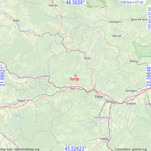
Vorţa GPS coordinates[2]
46° 1' 0.012" North, 22° 40' 59.988" East
| Map corner | latitude | longitude |
|---|---|---|
| Upper-left | 46.5028°, | 21.98021° |
| Center: | 46.01667°, | 22.68333° |
| Lower-right: | 45.52623°, | 23.38646° |
| Map W x H: | 108.6×108.6 km | = 67.5×67.5mi |
| max Lat: | 48.23793° ⇑44.6% North |
| Vorţa: | 46.01667° |
| min Lat: | ⇓55.4% South 43.65638° |
| min Long | Vorţa | max Long |
| 20.31667° | 22.68333° | 29.65403° |
| W 11.6%⇐ | ⇒88.4% E |
Elevation
Elevation of Vorţa is 292 m = 958 ft, and this is 37.1 m = 122 ft above average elevation for this country.
| Max E: |
1278 m = 4193 ft | 34.6% |
| Vorţa | 292 m 958 ft | |
| Avg. | 254.9 m = 836 ft | |
Min E: |
-2 m = -7 ft | 65.4% |
See also: Romania elevation on elevation.city.
Geographical zone
Vorţa is located in North temperate zone (between Tropic of Cancer and the Arctic Circle). Distance of this North polar circle is 2284.6 km =1419.6 mi to North.| Distance of | km | miles | from Vorţa |
|---|---|---|---|
| North Pole | 4890.5 | 3038.8 | to North |
| Arctic Circle | 2284.6 | 1419.6 | to North |
| Tropic Cancer | 2510.7 | 1560.1 | to South |
| Equator | 5116.6 | 3179.3 | to South |


Nearby cities:
15 places around Vorţa: (largest is in red/bold)
• Boz
9.3 km =5.8 mi,  144°
144°
• Brad
15.1 km =9.4 mi,  30°
30°
• Bretea Mureșană
9.1 km =5.7 mi,  166°
166°
• Brănişca
13.5 km =8.4 mi,  145°
145°
• Dobra
14.3 km =8.9 mi,  219°
219°
• Gurasada
9.7 km =6 mi, 224°
• Ilia
9.6 km =6 mi,  195°
195°
• Leșnic
12.2 km =7.6 mi,  158°
158°
• Luncoiu de Jos
11.3 km =7 mi, 34°
• Luncoiu de Sus
12 km =7.5 mi,  56°
56°
• Mesteacăn
15.4 km =9.6 mi,  23°
23°
• Ormindea
14.3 km =8.9 mi,  73°
73°
• Sârbi
6.4 km =4 mi, 163°
• Vălişoara
13.4 km =8.3 mi, 73°
• Țărățel
15.8 km =9.8 mi,  41°
41°
Sources, notices
• [Note1] Compared only with cities in Romania existing in our database
• [Src1] Map data: © OpenStreetMap contributors (CC-BY-SA)
• [Src2] Other city data from geonames.org with taken over terms of usage.
• [Src3] Geographical zone / Annual Mean Temperature by Robert A. Rohde @ Wikipedia
