Vișinii geodata
Vișinii (Călăraşi) is a populated place; located in Romania in Europe/Bucharest (GMT+3) time zone. With population of 622 people, there are 6068 cities with bigger population in this country. Compared to other cities in Romania, 90.9% of cities are located further ↑North; 86.6% of cities are located further ←West and 94.7% of cities have higher elevation than Vișinii. Note1


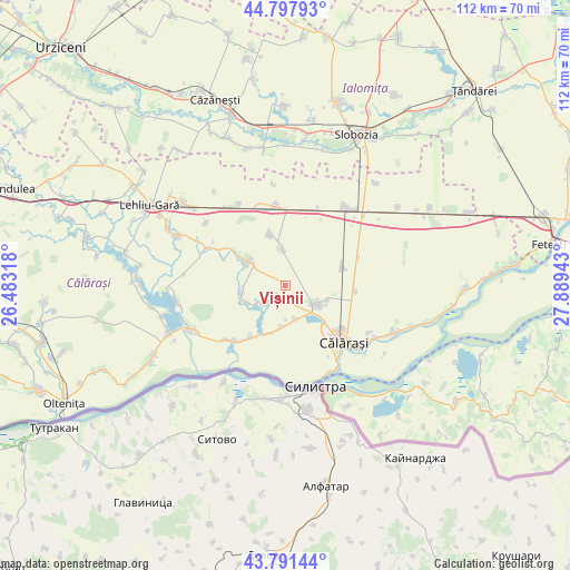
Vișinii GPS coordinates[2]
44° 17' 48.624" North, 27° 11' 10.68" East
| Map corner | latitude | longitude |
|---|---|---|
| Upper-left | 44.79793°, | 26.48318° |
| Center: | 44.29684°, | 27.1863° |
| Lower-right: | 43.79144°, | 27.88943° |
| Map W x H: | 111.9×111.9 km | = 69.5×69.5mi |
| max Lat: | 48.23793° ⇑90.9% North |
| Vișinii: | 44.29684° |
| min Lat: | ⇓9.1% South 43.65638° |
| min Long | Vișinii | max Long |
| 20.31667° | 27.1863° | 29.65403° |
| W 86.6%⇐ | ⇒13.4% E |
Elevation
Elevation of Vișinii is 36 m = 118 ft, and this is 218.9 m = 718 ft below average elevation for this country.
| Max E: |
1278 m = 4193 ft | 94.7% |
| Avg. | 254.9 m = 836 ft | |
| Vișinii | 36 m = 118 ft | |
Min E: |
-2 m = -7 ft | 5.3% |
See also: Romania elevation on elevation.city.
Geographical zone
Vișinii is located in North temperate zone (between Tropic of Cancer and the Arctic Circle). Distance of this Northern Tropic circle is 2319.4 km =1441.2 mi to South.| Distance of | km | miles | from Vișinii |
|---|---|---|---|
| North Pole | 5081.7 | 3157.6 | to North |
| Arctic Circle | 2475.8 | 1538.4 | to North |
| Tropic Cancer | 2319.4 | 1441.2 | to South |
| Equator | 4925.3 | 3060.4 | to South |


Nearby cities:
15 places around Vișinii: (largest is in red/bold)
• Alexandru Odobescu
8.9 km =5.5 mi,  247°
247°
• Ceacu
6.3 km =3.9 mi,  123°
123°
• Cunești
8.3 km =5.2 mi,  184°
184°
• Cuza Vodă
7.2 km =4.5 mi, 117°
• Călărașii Vechi
8.8 km =5.5 mi,  109°
109°
• Floroaica
7.1 km =4.4 mi,  357°
357°
• Grădiştea
7.5 km =4.7 mi,  161°
161°
• Independenţa
3.3 km =2.1 mi,  242°
242°
• Mihai Viteazu
10.7 km =6.6 mi,  302°
302°
• Nicolae Bălcescu
8.6 km =5.3 mi,  262°
262°
• Potcoava
5.7 km =3.5 mi,  229°
229°
• Rasa
9.7 km =6 mi,  198°
198°
• Vlad Ţepeş
10.1 km =6.3 mi,  305°
305°
• Vâlcelele
10.6 km =6.6 mi,  344°
344°
• Ştefan Vodă
10.6 km =6.6 mi,  78°
78°
Sources, notices
• [Note1] Compared only with cities in Romania existing in our database
• [Src1] Map data: © OpenStreetMap contributors (CC-BY-SA)
• [Src2] Other city data from geonames.org with taken over terms of usage.
• [Src3] Geographical zone / Annual Mean Temperature by Robert A. Rohde @ Wikipedia
