Floroaica geodata
Floroaica (Călăraşi) is a populated place; located in Romania in Europe/Bucharest (GMT+3) time zone. With population of 711 people, there are 5503 cities with bigger population in this country. Compared to other cities in Romania, 89.3% of cities are located further ↑North; 86.5% of cities are located further ←West and 93.5% of cities have higher elevation than Floroaica. Note1


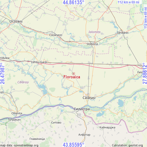
Floroaica GPS coordinates[2]
44° 21' 38.916" North, 27° 10' 58.764" East
| Map corner | latitude | longitude |
|---|---|---|
| Upper-left | 44.86135°, | 26.47987° |
| Center: | 44.36081°, | 27.18299° |
| Lower-right: | 43.85595°, | 27.88612° |
| Map W x H: | 111.8×111.8 km | = 69.5×69.5mi |
| max Lat: | 48.23793° ⇑89.3% North |
| Floroaica: | 44.36081° |
| min Lat: | ⇓10.7% South 43.65638° |
| min Long | Floroaica | max Long |
| 20.31667° | 27.18299° | 29.65403° |
| W 86.5%⇐ | ⇒13.5% E |
Elevation
Elevation of Floroaica is 41 m = 135 ft, and this is 213.9 m = 702 ft below average elevation for this country.
| Max E: |
1278 m = 4193 ft | 93.5% |
| Avg. | 254.9 m = 836 ft | |
| Floroaica | 41 m = 135 ft | |
Min E: |
-2 m = -7 ft | 6.5% |
See also: Romania elevation on elevation.city.
Geographical zone
Floroaica is located in North temperate zone (between Tropic of Cancer and the Arctic Circle). Distance of this Northern Tropic circle is 2326.5 km =1445.6 mi to South.| Distance of | km | miles | from Floroaica |
|---|---|---|---|
| North Pole | 5074.6 | 3153.2 | to North |
| Arctic Circle | 2468.7 | 1534 | to North |
| Tropic Cancer | 2326.5 | 1445.6 | to South |
| Equator | 4932.5 | 3064.9 | to South |


Nearby cities:
15 places around Floroaica: (largest is in red/bold)
• Alexandru Odobescu
13.1 km =8.1 mi,  217°
217°
• Ceacu
12 km =7.5 mi,  152°
152°
• Cuza Vodă
12.4 km =7.7 mi, 147°
• Călărașii Vechi
13.2 km =8.2 mi,  139°
139°
• Dragalina
13.3 km =8.3 mi,  52°
52°
• Dragoș Vodă
8.5 km =5.3 mi,  341°
341°
• Dâlga
12.6 km =7.8 mi,  316°
316°
• Independenţa
9 km =5.6 mi,  196°
196°
• Mihai Viteazu
8.8 km =5.5 mi,  261°
261°
• Nicolae Bălcescu
11.7 km =7.3 mi, 224°
• Potcoava
11.6 km =7.2 mi, 200°
• Vișinii
7.1 km =4.4 mi,  177°
177°
• Vlad Ţepeş
8 km =5 mi, 261°
• Vâlcelele
4 km =2.5 mi, 319°
• Ştefan Vodă
11.7 km =7.3 mi,  114°
114°
Sources, notices
• [Note1] Compared only with cities in Romania existing in our database
• [Src1] Map data: © OpenStreetMap contributors (CC-BY-SA)
• [Src2] Other city data from geonames.org with taken over terms of usage.
• [Src3] Geographical zone / Annual Mean Temperature by Robert A. Rohde @ Wikipedia
