Vintere geodata
Vintere (Bihor) is a populated place; located in Romania in Europe/Bucharest (GMT+3) time zone. With population of 1,009 people, there are 4268 cities with bigger population in this country. Compared to other cities in Romania, 73.4% of cities are located further ↓South; 93.2% of cities are located further →East and 62% of cities have higher elevation than Vintere. Note1


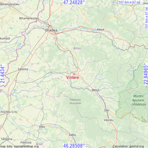
Vintere GPS coordinates[2]
46° 46' 7.788" North, 22° 8' 47.472" East
| Map corner | latitude | longitude |
|---|---|---|
| Upper-left | 47.24828°, | 21.4434° |
| Center: | 46.76883°, | 22.14652° |
| Lower-right: | 46.28508°, | 22.84965° |
| Map W x H: | 107.1×107.1 km | = 66.5×66.5mi |
| max Lat: | 48.23793° ⇑26.6% North |
| Vintere: | 46.76883° |
| min Lat: | ⇓73.4% South 43.65638° |
| min Long | Vintere | max Long |
| 20.31667° | 22.14652° | 29.65403° |
| W 6.8%⇐ | ⇒93.2% E |
Elevation
Elevation of Vintere is 159 m = 522 ft, and this is 95.9 m = 315 ft below average elevation for this country.
| Max E: |
1278 m = 4193 ft | 62% |
| Avg. | 254.9 m = 836 ft | |
| Vintere | 159 m = 522 ft | |
Min E: |
-2 m = -7 ft | 38% |
See also: Romania elevation on elevation.city.
Geographical zone
Vintere is located in North temperate zone (between Tropic of Cancer and the Arctic Circle). Distance of this North polar circle is 2201 km =1367.6 mi to North.| Distance of | km | miles | from Vintere |
|---|---|---|---|
| North Pole | 4806.9 | 2986.9 | to North |
| Arctic Circle | 2201 | 1367.6 | to North |
| Tropic Cancer | 2594.3 | 1612 | to South |
| Equator | 5200.2 | 3231.3 | to South |


Nearby cities:
15 places around Vintere: (largest is in red/bold)
• Căpâlna
5.3 km =3.3 mi,  221°
221°
• Dumbrava
6.1 km =3.8 mi,  287°
287°
• Dușești
8 km =5 mi,  18°
18°
• Forău
7.7 km =4.8 mi,  147°
147°
• Hidiș
8.8 km =5.5 mi,  83°
83°
• Holod
1.9 km =1.2 mi,  328°
328°
• Lupoaia
4.1 km =2.5 mi,  338°
338°
• Petid
7.7 km =4.8 mi, 223°
• Prisaca
8.9 km =5.5 mi,  136°
136°
• Răbăgani
6.9 km =4.3 mi,  107°
107°
• Suplacu de Tinca
7.4 km =4.6 mi,  199°
199°
• Sâmbăta
5.7 km =3.5 mi,  49°
49°
• Săldăbagiu Mic
3.4 km =2.1 mi,  170°
170°
• Urviș de Beiuș
8.5 km =5.3 mi, 173°
• Vărășeni
5.1 km =3.2 mi,  91°
91°
Sources, notices
• [Note1] Compared only with cities in Romania existing in our database
• [Src1] Map data: © OpenStreetMap contributors (CC-BY-SA)
• [Src2] Other city data from geonames.org with taken over terms of usage.
• [Src3] Geographical zone / Annual Mean Temperature by Robert A. Rohde @ Wikipedia
