Răbăgani geodata
Răbăgani (Bihor) is a seat of a second-order administrative division; located in Romania in Europe/Bucharest (GMT+3) time zone. With population of 2,269 people, there are 2352 cities with bigger population in this country. Compared to other cities in Romania, 72.8% of cities are located further ↓South; 92.5% of cities are located further →East and 65.7% of cities have higher elevation than Răbăgani. Note1


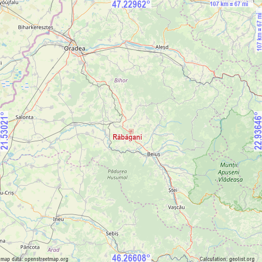
Răbăgani GPS coordinates[2]
46° 45' 0" North, 22° 13' 59.988" East
| Map corner | latitude | longitude |
|---|---|---|
| Upper-left | 47.22962°, | 21.53021° |
| Center: | 46.75°, | 22.23333° |
| Lower-right: | 46.26608°, | 22.93646° |
| Map W x H: | 107.1×107.1 km | = 66.5×66.5mi |
| max Lat: | 48.23793° ⇑27.2% North |
| Răbăgani: | 46.75° |
| min Lat: | ⇓72.8% South 43.65638° |
| min Long | Răbăgani | max Long |
| 20.31667° | 22.23333° | 29.65403° |
| W 7.5%⇐ | ⇒92.5% E |
Elevation
Elevation of Răbăgani is 144 m = 472 ft, and this is 110.9 m = 364 ft below average elevation for this country.
| Max E: |
1278 m = 4193 ft | 65.7% |
| Avg. | 254.9 m = 836 ft | |
| Răbăgani | 144 m = 472 ft | |
Min E: |
-2 m = -7 ft | 34.3% |
See also: Romania elevation on elevation.city.
Geographical zone
Răbăgani is located in North temperate zone (between Tropic of Cancer and the Arctic Circle). Distance of this North polar circle is 2203.1 km =1368.9 mi to North.| Distance of | km | miles | from Răbăgani |
|---|---|---|---|
| North Pole | 4808.9 | 2988.1 | to North |
| Arctic Circle | 2203.1 | 1368.9 | to North |
| Tropic Cancer | 2592.2 | 1610.7 | to South |
| Equator | 5198.1 | 3229.9 | to South |


Nearby cities:
15 places around Răbăgani: (largest is in red/bold)
• Coșdeni
3.8 km =2.4 mi,  55°
55°
• Drăgoteni
6.1 km =3.8 mi,  108°
108°
• Feneriș
5.9 km =3.7 mi,  135°
135°
• Forău
5 km =3.1 mi,  209°
209°
• Hidiș
3.8 km =2.4 mi,  33°
33°
• Pocola
8.3 km =5.2 mi,  152°
152°
• Pomezeu
5.3 km =3.3 mi,  45°
45°
• Prisaca
4.3 km =2.7 mi,  185°
185°
• Sâmbăta
6.2 km =3.9 mi,  338°
338°
• Săldăbagiu Mic
6.2 km =3.9 mi,  258°
258°
• Săucani
3.1 km =1.9 mi,  125°
125°
• Uileacu de Beiuș
7.2 km =4.5 mi, 187°
• Vintere
6.9 km =4.3 mi,  287°
287°
• Vălani de Pomezeu
8.1 km =5 mi, 59°
• Vărășeni
2.5 km =1.6 mi,  322°
322°
Sources, notices
• [Note1] Compared only with cities in Romania existing in our database
• [Src1] Map data: © OpenStreetMap contributors (CC-BY-SA)
• [Src2] Other city data from geonames.org with taken over terms of usage.
• [Src3] Geographical zone / Annual Mean Temperature by Robert A. Rohde @ Wikipedia
