Vedea geodata
Vedea (Giurgiu) is a seat of a second-order administrative division; located in Romania in Europe/Bucharest (GMT+3) time zone. With population of 5,785 people, there are 583 cities with bigger population in this country. Compared to other cities in Romania, 99.6% of cities are located further ↑North; 58.8% of cities are located further ←West and 96.4% of cities have higher elevation than Vedea. Note1


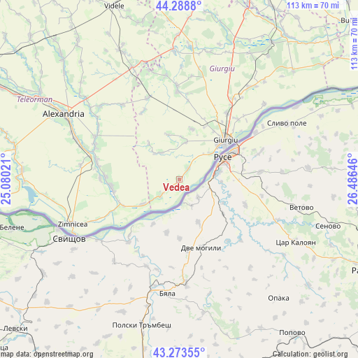
Vedea GPS coordinates[2]
43° 46' 59.988" North, 25° 46' 59.988" East
| Map corner | latitude | longitude |
|---|---|---|
| Upper-left | 44.2888°, | 25.08021° |
| Center: | 43.78333°, | 25.78333° |
| Lower-right: | 43.27355°, | 26.48646° |
| Map W x H: | 112.9×112.9 km | = 70.2×70.2mi |
| max Lat: | 48.23793° ⇑99.6% North |
| Vedea: | 43.78333° |
| min Lat: | ⇓0.4% South 43.65638° |
| min Long | Vedea | max Long |
| 20.31667° | 25.78333° | 29.65403° |
| W 58.8%⇐ | ⇒41.2% E |
Elevation
Elevation of Vedea is 27 m = 89 ft, and this is 227.9 m = 748 ft below average elevation for this country.
| Max E: |
1278 m = 4193 ft | 96.4% |
| Avg. | 254.9 m = 836 ft | |
| Vedea | 27 m = 89 ft | |
Min E: |
-2 m = -7 ft | 3.6% |
See also: Romania elevation on elevation.city.
Geographical zone
Vedea is located in North temperate zone (between Tropic of Cancer and the Arctic Circle). Distance of this Northern Tropic circle is 2262.3 km =1405.7 mi to South.| Distance of | km | miles | from Vedea |
|---|---|---|---|
| North Pole | 5138.8 | 3193.1 | to North |
| Arctic Circle | 2532.9 | 1573.9 | to North |
| Tropic Cancer | 2262.3 | 1405.7 | to South |
| Equator | 4868.2 | 3025 | to South |


Nearby cities:
15 places around Vedea: (largest is in red/bold)
• Bujoru
18.9 km =11.7 mi,  246°
246°
• Bălanu
18.6 km =11.6 mi,  35°
35°
• Ghizdaru
18.3 km =11.4 mi,  25°
25°
• Giurgiu
18.4 km =11.4 mi,  51°
51°
• Gogoşari
11.4 km =7.1 mi,  324°
324°
• Găujani
8.7 km =5.4 mi,  230°
230°
• Hodivoaia
13.4 km =8.3 mi,  3°
3°
• Izvoru
14.8 km =9.2 mi, 319°
• Malu
4.5 km =2.8 mi, 38°
• Pietrișu
10.9 km =6.8 mi, 233°
• Pietroşani
13.6 km =8.5 mi,  235°
235°
• Putineiu
13.6 km =8.5 mi,  342°
342°
• Slobozia
11.9 km =7.4 mi, 51°
• Stăneşti
15.4 km =9.6 mi,  15°
15°
• Vieru
11.8 km =7.3 mi,  10°
10°
Sources, notices
• [Note1] Compared only with cities in Romania existing in our database
• [Src1] Map data: © OpenStreetMap contributors (CC-BY-SA)
• [Src2] Other city data from geonames.org with taken over terms of usage.
• [Src3] Geographical zone / Annual Mean Temperature by Robert A. Rohde @ Wikipedia
