Vălcani geodata
Vălcani (Timiş) is a seat of a second-order administrative division; located in Romania in Europe/Bucharest (GMT+3) time zone. With population of 1,279 people, there are 3564 cities with bigger population in this country. Compared to other cities in Romania, 55.1% of cities are located further ↓South; 100% of cities are located further →East and 86.2% of cities have higher elevation than Vălcani. Note1


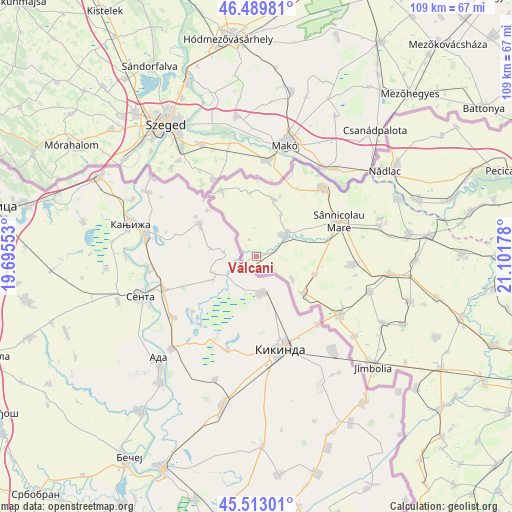
Vălcani GPS coordinates[2]
46° 0' 12.852" North, 20° 23' 55.14" East
| Map corner | latitude | longitude |
|---|---|---|
| Upper-left | 46.48981°, | 19.69553° |
| Center: | 46.00357°, | 20.39865° |
| Lower-right: | 45.51301°, | 21.10178° |
| Map W x H: | 108.6×108.6 km | = 67.5×67.5mi |
| max Lat: | 48.23793° ⇑44.9% North |
| Vălcani: | 46.00357° |
| min Lat: | ⇓55.1% South 43.65638° |
| min Long | Vălcani | max Long |
| 20.31667° | 20.39865° | 29.65403° |
| W 0%⇐ | ⇒100% E |
Elevation
Elevation of Vălcani is 74 m = 243 ft, and this is 180.9 m = 594 ft below average elevation for this country.
| Max E: |
1278 m = 4193 ft | 86.2% |
| Avg. | 254.9 m = 836 ft | |
| Vălcani | 74 m = 243 ft | |
Min E: |
-2 m = -7 ft | 13.8% |
See also: Romania elevation on elevation.city.
Geographical zone
Vălcani is located in North temperate zone (between Tropic of Cancer and the Arctic Circle). Distance of this North polar circle is 2286.1 km =1420.5 mi to North.| Distance of | km | miles | from Vălcani |
|---|---|---|---|
| North Pole | 4891.9 | 3039.7 | to North |
| Arctic Circle | 2286.1 | 1420.5 | to North |
| Tropic Cancer | 2509.2 | 1559.1 | to South |
| Equator | 5115.1 | 3178.4 | to South |


Nearby cities:
15 places around Vălcani: (largest is in red/bold)
• Beba Veche
15.8 km =9.8 mi,  336°
336°
• Cenad
20.3 km =12.6 mi,  44°
44°
• Cheglevici
12.6 km =7.8 mi,  16°
16°
• Cherestur
13.7 km =8.5 mi,  354°
354°
• Comloşu Mare
21.7 km =13.5 mi,  125°
125°
• Comloșu Mic
26.8 km =16.7 mi, 128°
• Dudeştii Vechi
8.3 km =5.2 mi,  51°
51°
• Gottlob
25.3 km =15.7 mi,  107°
107°
• Lunga
20 km =12.4 mi, 131°
• Nerău
13.1 km =8.1 mi, 106°
• Saravale
27.4 km =17 mi,  74°
74°
• Sânnicolau Mare
20.2 km =12.6 mi,  63°
63°
• Teremia Mare
12.4 km =7.7 mi, 127°
• Teremia Mică
9.2 km =5.7 mi,  123°
123°
• Tomnatic
20.4 km =12.7 mi,  94°
94°
Sources, notices
• [Note1] Compared only with cities in Romania existing in our database
• [Src1] Map data: © OpenStreetMap contributors (CC-BY-SA)
• [Src2] Other city data from geonames.org with taken over terms of usage.
• [Src3] Geographical zone / Annual Mean Temperature by Robert A. Rohde @ Wikipedia
