Văcărești geodata
Văcărești (Teleorman) is a populated place; located in Romania in Europe/Bucharest (GMT+3) time zone. With population of 660 people, there are 5817 cities with bigger population in this country. Compared to other cities in Romania, 94.7% of cities are located further ↑North; 52.3% of cities are located further →East and 77% of cities have higher elevation than Văcărești. Note1


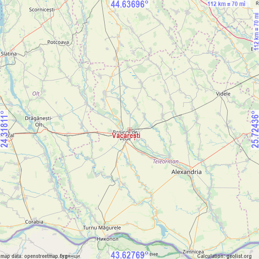
Văcărești GPS coordinates[2]
44° 8' 4.128" North, 25° 1' 16.428" East
| Map corner | latitude | longitude |
|---|---|---|
| Upper-left | 44.63696°, | 24.31811° |
| Center: | 44.13448°, | 25.02123° |
| Lower-right: | 43.62769°, | 25.72436° |
| Map W x H: | 112.2×112.2 km | = 69.7×69.7mi |
| max Lat: | 48.23793° ⇑94.7% North |
| Văcărești: | 44.13448° |
| min Lat: | ⇓5.3% South 43.65638° |
| min Long | Văcărești | max Long |
| 20.31667° | 25.02123° | 29.65403° |
| W 47.7%⇐ | ⇒52.3% E |
Elevation
Elevation of Văcărești is 104 m = 341 ft, and this is 150.9 m = 495 ft below average elevation for this country.
| Max E: |
1278 m = 4193 ft | 77% |
| Avg. | 254.9 m = 836 ft | |
| Văcărești | 104 m = 341 ft | |
Min E: |
-2 m = -7 ft | 23% |
See also: Romania elevation on elevation.city.
Geographical zone
Văcărești is located in North temperate zone (between Tropic of Cancer and the Arctic Circle). Distance of this Northern Tropic circle is 2301.4 km =1430 mi to South.| Distance of | km | miles | from Văcărești |
|---|---|---|---|
| North Pole | 5099.8 | 3168.9 | to North |
| Arctic Circle | 2493.9 | 1549.6 | to North |
| Tropic Cancer | 2301.4 | 1430 | to South |
| Equator | 4907.3 | 3049.3 | to South |


Nearby cities:
15 places around Văcărești: (largest is in red/bold)
• Brebina
5.2 km =3.2 mi,  313°
313°
• Butculești
9.8 km =6.1 mi,  24°
24°
• Coșoteni
1.5 km =0.9 mi,  166°
166°
• Cucueți
8 km =5 mi, 313°
• Drăcşani
9.6 km =6 mi,  341°
341°
• Drăgăneşti de Vede
2.3 km =1.4 mi,  93°
93°
• Dulceanca
8.5 km =5.3 mi,  125°
125°
• Meri
4.6 km =2.9 mi,  145°
145°
• Măldăeni
7.3 km =4.5 mi,  254°
254°
• Roșiorii de Vede
3.6 km =2.2 mi,  236°
236°
• Rădoiești-Deal
9.1 km =5.7 mi,  79°
79°
• Rădoiești-Vale
10.6 km =6.6 mi, 82°
• Scrioaştea
5.9 km =3.7 mi,  286°
286°
• Sfinţeşti
8.3 km =5.2 mi,  49°
49°
• Vedea
6.7 km =4.2 mi, 147°
Sources, notices
• [Note1] Compared only with cities in Romania existing in our database
• [Src1] Map data: © OpenStreetMap contributors (CC-BY-SA)
• [Src2] Other city data from geonames.org with taken over terms of usage.
• [Src3] Geographical zone / Annual Mean Temperature by Robert A. Rohde @ Wikipedia
