Coșoteni geodata
Coșoteni (Teleorman) is a populated place; located in Romania in Europe/Bucharest (GMT+3) time zone. With population of 586 people, there are 6316 cities with bigger population in this country. Compared to other cities in Romania, 95% of cities are located further ↑North; 52.3% of cities are located further →East and 77.7% of cities have higher elevation than Coșoteni. Note1


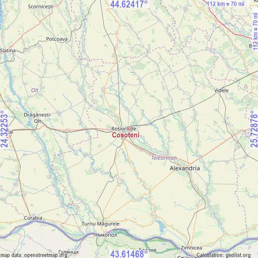
Coșoteni GPS coordinates[2]
44° 7' 17.688" North, 25° 1' 32.34" East
| Map corner | latitude | longitude |
|---|---|---|
| Upper-left | 44.62417°, | 24.32253° |
| Center: | 44.12158°, | 25.02565° |
| Lower-right: | 43.61468°, | 25.72878° |
| Map W x H: | 112.2×112.2 km | = 69.7×69.7mi |
| max Lat: | 48.23793° ⇑95% North |
| Coșoteni: | 44.12158° |
| min Lat: | ⇓5% South 43.65638° |
| min Long | Coșoteni | max Long |
| 20.31667° | 25.02565° | 29.65403° |
| W 47.7%⇐ | ⇒52.3% E |
Elevation
Elevation of Coșoteni is 102 m = 335 ft, and this is 152.9 m = 502 ft below average elevation for this country.
| Max E: |
1278 m = 4193 ft | 77.7% |
| Avg. | 254.9 m = 836 ft | |
| Coșoteni | 102 m = 335 ft | |
Min E: |
-2 m = -7 ft | 22.3% |
See also: Romania elevation on elevation.city.
Geographical zone
Coșoteni is located in North temperate zone (between Tropic of Cancer and the Arctic Circle). Distance of this Northern Tropic circle is 2299.9 km =1429.1 mi to South.| Distance of | km | miles | from Coșoteni |
|---|---|---|---|
| North Pole | 5101.2 | 3169.7 | to North |
| Arctic Circle | 2495.3 | 1550.5 | to North |
| Tropic Cancer | 2299.9 | 1429.1 | to South |
| Equator | 4905.9 | 3048.4 | to South |


Nearby cities:
15 places around Coșoteni: (largest is in red/bold)
• Albești
9.6 km =6 mi,  128°
128°
• Brebina
6.5 km =4 mi,  320°
320°
• Cucueți
9.3 km =5.8 mi, 318°
• Drăgăneşti de Vede
2.3 km =1.4 mi,  56°
56°
• Dulceanca
7.4 km =4.6 mi,  118°
118°
• Meri
3.3 km =2.1 mi,  136°
136°
• Măldăeni
7.4 km =4.6 mi,  265°
265°
• Peretu
9.2 km =5.7 mi,  149°
149°
• Roșiorii de Vede
3.4 km =2.1 mi,  260°
260°
• Rădoiești-Deal
9.2 km =5.7 mi,  69°
69°
• Rădoiești-Vale
10.6 km =6.6 mi, 74°
• Scrioaştea
6.8 km =4.2 mi,  297°
297°
• Sfinţeşti
9.1 km =5.7 mi,  40°
40°
• Vedea
5.4 km =3.4 mi, 142°
• Văcărești
1.5 km =0.9 mi,  346°
346°
Sources, notices
• [Note1] Compared only with cities in Romania existing in our database
• [Src1] Map data: © OpenStreetMap contributors (CC-BY-SA)
• [Src2] Other city data from geonames.org with taken over terms of usage.
• [Src3] Geographical zone / Annual Mean Temperature by Robert A. Rohde @ Wikipedia
