Uriu geodata
Uriu (Bistriţa-Năsăud) is a seat of a second-order administrative division; located in Romania in Europe/Bucharest (GMT+3) time zone. With population of 3,572 people, there are 1392 cities with bigger population in this country. Compared to other cities in Romania, 83.9% of cities are located further ↓South; 68.6% of cities are located further →East and 56.9% of cities have lower elevation than Uriu. Note1


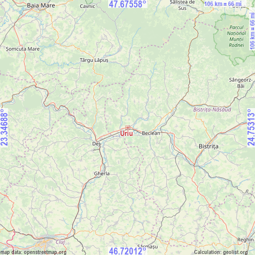
Uriu GPS coordinates[2]
47° 12' 0" North, 24° 3' 0" East
| Map corner | latitude | longitude |
|---|---|---|
| Upper-left | 47.67558°, | 23.34688° |
| Center: | 47.2°, | 24.05° |
| Lower-right: | 46.72012°, | 24.75313° |
| Map W x H: | 106.2×106.2 km | = 66×66mi |
| max Lat: | 48.23793° ⇑16.1% North |
| Uriu: | 47.2° |
| min Lat: | ⇓83.9% South 43.65638° |
| min Long | Uriu | max Long |
| 20.31667° | 24.05° | 29.65403° |
| W 31.4%⇐ | ⇒68.6% E |
Elevation
Elevation of Uriu is 247 m = 810 ft, and this is 7.9 m = 26 ft below average elevation for this country.
| Max E: |
1278 m = 4193 ft | 43.1% |
| Avg. | 254.9 m = 836 ft | |
| Uriu | 247 m = 810 ft | |
Min E: |
-2 m = -7 ft | 56.9% |
See also: Romania elevation on elevation.city.
Geographical zone
Uriu is located in North temperate zone (between Tropic of Cancer and the Arctic Circle). Distance of this North polar circle is 2153 km =1337.8 mi to North.| Distance of | km | miles | from Uriu |
|---|---|---|---|
| North Pole | 4758.9 | 2957 | to North |
| Arctic Circle | 2153 | 1337.8 | to North |
| Tropic Cancer | 2642.2 | 1641.8 | to South |
| Equator | 5248.1 | 3261 | to South |


Nearby cities:
15 places around Uriu: (largest is in red/bold)
• Bața
4.3 km =2.7 mi,  252°
252°
• Braniştea
3.9 km =2.4 mi,  161°
161°
• Ciceu-Giurgeşti
6.1 km =3.8 mi,  335°
335°
• Ciceu-Mihăiești
5.9 km =3.7 mi, 254°
• Cireșoaia
6.4 km =4 mi,  171°
171°
• Coldău
6.7 km =4.2 mi,  108°
108°
• Cristeștii Ciceului
3.6 km =2.2 mi,  102°
102°
• Căianu Mic
8.4 km =5.2 mi,  63°
63°
• Dobric
7.9 km =4.9 mi,  48°
48°
• Ilișua
3.7 km =2.3 mi, 55°
• Măluț
5.1 km =3.2 mi,  126°
126°
• Mănășturel
8 km =5 mi, 246°
• Negrilești
7.9 km =4.9 mi,  359°
359°
• Reteag
2.4 km =1.5 mi,  258°
258°
• Sânmărghita
6.4 km =4 mi,  220°
220°
Sources, notices
• [Note1] Compared only with cities in Romania existing in our database
• [Src1] Map data: © OpenStreetMap contributors (CC-BY-SA)
• [Src2] Other city data from geonames.org with taken over terms of usage.
• [Src3] Geographical zone / Annual Mean Temperature by Robert A. Rohde @ Wikipedia
