Braniştea geodata
Braniştea (Bistriţa-Năsăud) is a seat of a second-order administrative division; located in Romania in Europe/Bucharest (GMT+3) time zone. With population of 3,347 people, there are 1525 cities with bigger population in this country. Compared to other cities in Romania, 83% of cities are located further ↓South; 68.3% of cities are located further →East and 68.4% of cities have lower elevation than Braniştea. Note1


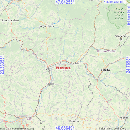
Braniştea GPS coordinates[2]
47° 10' 0.012" North, 24° 4' 0.012" East
| Map corner | latitude | longitude |
|---|---|---|
| Upper-left | 47.64255°, | 23.36355° |
| Center: | 47.16667°, | 24.06667° |
| Lower-right: | 46.68649°, | 24.7698° |
| Map W x H: | 106.3×106.3 km | = 66.1×66.1mi |
| max Lat: | 48.23793° ⇑17% North |
| Braniştea: | 47.16667° |
| min Lat: | ⇓83% South 43.65638° |
| min Long | Braniştea | max Long |
| 20.31667° | 24.06667° | 29.65403° |
| W 31.7%⇐ | ⇒68.3% E |
Elevation
Elevation of Braniştea is 309 m = 1014 ft, and this is 54.1 m = 177 ft above average elevation for this country.
| Max E: |
1278 m = 4193 ft | 31.6% |
| Braniştea | 309 m 1014 ft | |
| Avg. | 254.9 m = 836 ft | |
Min E: |
-2 m = -7 ft | 68.4% |
See also: Romania elevation on elevation.city.
Geographical zone
Braniştea is located in North temperate zone (between Tropic of Cancer and the Arctic Circle). Distance of this North polar circle is 2156.7 km =1340.1 mi to North.| Distance of | km | miles | from Braniştea |
|---|---|---|---|
| North Pole | 4762.6 | 2959.3 | to North |
| Arctic Circle | 2156.7 | 1340.1 | to North |
| Tropic Cancer | 2638.5 | 1639.5 | to South |
| Equator | 5244.4 | 3258.7 | to South |


Nearby cities:
15 places around Braniştea: (largest is in red/bold)
• Bața
5.9 km =3.7 mi,  294°
294°
• Beclean
9 km =5.6 mi,  78°
78°
• Ciceu-Mihăiești
7.3 km =4.5 mi, 286°
• Cireșoaia
2.7 km =1.7 mi,  187°
187°
• Coldău
5.3 km =3.3 mi,  72°
72°
• Cristeștii Ciceului
3.7 km =2.3 mi,  36°
36°
• Ilișua
6.1 km =3.8 mi,  17°
17°
• Malin
7.5 km =4.7 mi,  134°
134°
• Măluț
3 km =1.9 mi, 76°
• Mănășturel
8.6 km =5.3 mi,  273°
273°
• Nireș
8.7 km =5.4 mi,  228°
228°
• Reteag
4.9 km =3 mi,  311°
311°
• Sânmărghita
5.6 km =3.5 mi,  258°
258°
• Unguraş
5.7 km =3.5 mi, 192°
• Uriu
3.9 km =2.4 mi,  341°
341°
Sources, notices
• [Note1] Compared only with cities in Romania existing in our database
• [Src1] Map data: © OpenStreetMap contributors (CC-BY-SA)
• [Src2] Other city data from geonames.org with taken over terms of usage.
• [Src3] Geographical zone / Annual Mean Temperature by Robert A. Rohde @ Wikipedia
