Ungra geodata
Ungra (Braşov) is a seat of a second-order administrative division; located in Romania in Europe/Bucharest (GMT+3) time zone. With population of 1,983 people, there are 2619 cities with bigger population in this country. Compared to other cities in Romania, 54.7% of cities are located further ↓South; 50.8% of cities are located further ←West and 85.5% of cities have lower elevation than Ungra. Note1


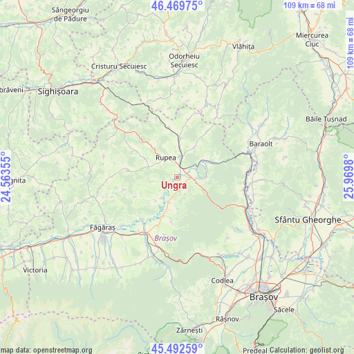
Ungra GPS coordinates[2]
45° 58' 59.988" North, 25° 16' 0.012" East
| Map corner | latitude | longitude |
|---|---|---|
| Upper-left | 46.46975°, | 24.56355° |
| Center: | 45.98333°, | 25.26667° |
| Lower-right: | 45.49259°, | 25.9698° |
| Map W x H: | 108.7×108.6 km | = 67.5×67.5mi |
| max Lat: | 48.23793° ⇑45.3% North |
| Ungra: | 45.98333° |
| min Lat: | ⇓54.7% South 43.65638° |
| min Long | Ungra | max Long |
| 20.31667° | 25.26667° | 29.65403° |
| W 50.8%⇐ | ⇒49.2% E |
Elevation
Elevation of Ungra is 452 m = 1483 ft, and this is 197.1 m = 647 ft above average elevation for this country.
| Max E: |
1278 m = 4193 ft | 14.5% |
| Ungra | 452 m 1483 ft | |
| Avg. | 254.9 m = 836 ft | |
Min E: |
-2 m = -7 ft | 85.5% |
See also: Romania elevation on elevation.city.
Geographical zone
Ungra is located in North temperate zone (between Tropic of Cancer and the Arctic Circle). Distance of this North polar circle is 2288.3 km =1421.9 mi to North.| Distance of | km | miles | from Ungra |
|---|---|---|---|
| North Pole | 4894.2 | 3041.1 | to North |
| Arctic Circle | 2288.3 | 1421.9 | to North |
| Tropic Cancer | 2506.9 | 1557.7 | to South |
| Equator | 5112.9 | 3177 | to South |


Nearby cities:
15 places around Ungra: (largest is in red/bold)
• Caţa
11.1 km =6.9 mi,  0°
0°
• Comana de Jos
8.2 km =5.1 mi,  199°
199°
• Comana de Sus
9.3 km =5.8 mi,  180°
180°
• Crihalma
8.1 km =5 mi,  218°
218°
• Cuciulata
4.4 km =2.7 mi,  171°
171°
• Dacia
9.2 km =5.7 mi,  288°
288°
• Dopca
9.2 km =5.7 mi,  89°
89°
• Dăișoara
7.7 km =4.8 mi,  260°
260°
• Hoghiz
2.6 km =1.6 mi, 90°
• Homorod
7.4 km =4.6 mi, 0°
• Mercheașa
10.7 km =6.6 mi,  30°
30°
• Racoș
12.1 km =7.5 mi,  67°
67°
• Rupea
6.8 km =4.2 mi,  325°
325°
• Ticușu Nou
9.8 km =6.1 mi, 222°
• Veneția de Jos
12.7 km =7.9 mi, 199°
Sources, notices
• [Note1] Compared only with cities in Romania existing in our database
• [Src1] Map data: © OpenStreetMap contributors (CC-BY-SA)
• [Src2] Other city data from geonames.org with taken over terms of usage.
• [Src3] Geographical zone / Annual Mean Temperature by Robert A. Rohde @ Wikipedia
