Dacia geodata
Dacia (Braşov) is a populated place; located in Romania in Europe/Bucharest (GMT+3) time zone. With population of 724 people, there are 5440 cities with bigger population in this country. Compared to other cities in Romania, 55.2% of cities are located further ↓South; 50.6% of cities are located further →East and 87.3% of cities have lower elevation than Dacia. Note1


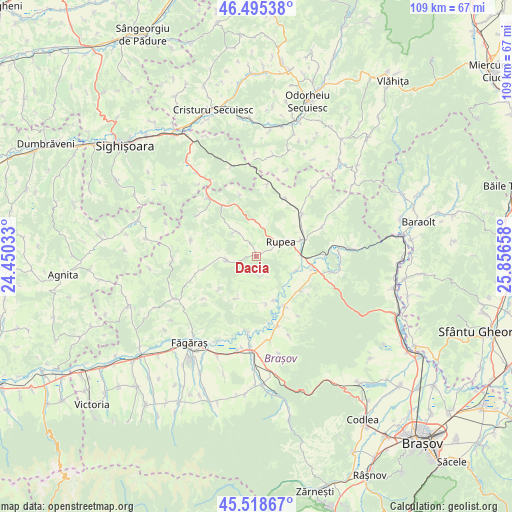
Dacia GPS coordinates[2]
46° 0' 33.048" North, 25° 9' 12.42" East
| Map corner | latitude | longitude |
|---|---|---|
| Upper-left | 46.49538°, | 24.45033° |
| Center: | 46.00918°, | 25.15345° |
| Lower-right: | 45.51867°, | 25.85658° |
| Map W x H: | 108.6×108.6 km | = 67.5×67.5mi |
| max Lat: | 48.23793° ⇑44.8% North |
| Dacia: | 46.00918° |
| min Lat: | ⇓55.2% South 43.65638° |
| min Long | Dacia | max Long |
| 20.31667° | 25.15345° | 29.65403° |
| W 49.4%⇐ | ⇒50.6% E |
Elevation
Elevation of Dacia is 474 m = 1555 ft, and this is 219.1 m = 719 ft above average elevation for this country.
| Max E: |
1278 m = 4193 ft | 12.7% |
| Dacia | 474 m 1555 ft | |
| Avg. | 254.9 m = 836 ft | |
Min E: |
-2 m = -7 ft | 87.3% |
See also: Romania elevation on elevation.city.
Geographical zone
Dacia is located in North temperate zone (between Tropic of Cancer and the Arctic Circle). Distance of this North polar circle is 2285.4 km =1420.1 mi to North.| Distance of | km | miles | from Dacia |
|---|---|---|---|
| North Pole | 4891.3 | 3039.3 | to North |
| Arctic Circle | 2285.4 | 1420.1 | to North |
| Tropic Cancer | 2509.8 | 1559.5 | to South |
| Equator | 5115.7 | 3178.7 | to South |


Nearby cities:
15 places around Dacia: (largest is in red/bold)
• Buneşti
12.9 km =8 mi,  321°
321°
• Caţa
12 km =7.5 mi,  46°
46°
• Comana de Jos
12.2 km =7.6 mi,  150°
150°
• Crihalma
10 km =6.2 mi,  157°
157°
• Cuciulata
11.9 km =7.4 mi,  127°
127°
• Dăișoara
4.3 km =2.7 mi, 164°
• Fișer
7.8 km =4.8 mi,  358°
358°
• Hoghiz
11.7 km =7.3 mi,  104°
104°
• Homorod
9.8 km =6.1 mi,  62°
62°
• Jibert
6.8 km =4.2 mi,  261°
261°
• Rupea
5.6 km =3.5 mi, 61°
• Ticuşu Vechi
9.4 km =5.8 mi,  206°
206°
• Ticușu Nou
10.3 km =6.4 mi,  167°
167°
• Ungra
9.2 km =5.7 mi,  108°
108°
• Viscri
6.9 km =4.3 mi, 318°
Sources, notices
• [Note1] Compared only with cities in Romania existing in our database
• [Src1] Map data: © OpenStreetMap contributors (CC-BY-SA)
• [Src2] Other city data from geonames.org with taken over terms of usage.
• [Src3] Geographical zone / Annual Mean Temperature by Robert A. Rohde @ Wikipedia
