Uda geodata
Uda (Arges) is a seat of a second-order administrative division; located in Romania in Europe/Bucharest (GMT+3) time zone. With population of 2,567 people, there are 2106 cities with bigger population in this country. Compared to other cities in Romania, 72.6% of cities are located further ↑North; 59.4% of cities are located further →East and 85.1% of cities have lower elevation than Uda. Note1


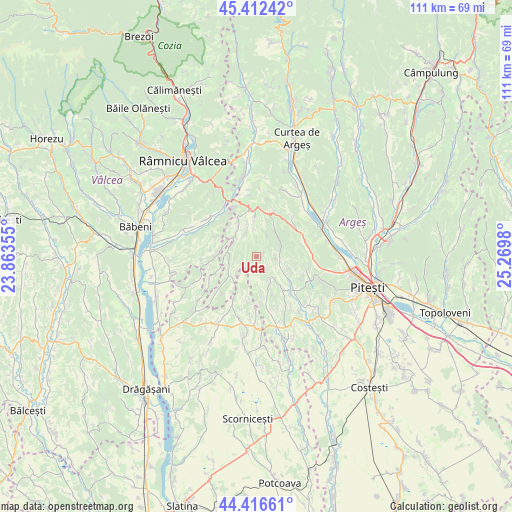
Uda GPS coordinates[2]
44° 55' 0.012" North, 24° 34' 0.012" East
| Map corner | latitude | longitude |
|---|---|---|
| Upper-left | 45.41242°, | 23.86355° |
| Center: | 44.91667°, | 24.56667° |
| Lower-right: | 44.41661°, | 25.2698° |
| Map W x H: | 110.7×110.7 km | = 68.8×68.8mi |
| max Lat: | 48.23793° ⇑72.6% North |
| Uda: | 44.91667° |
| min Lat: | ⇓27.4% South 43.65638° |
| min Long | Uda | max Long |
| 20.31667° | 24.56667° | 29.65403° |
| W 40.6%⇐ | ⇒59.4% E |
Elevation
Elevation of Uda is 446 m = 1463 ft, and this is 191.1 m = 627 ft above average elevation for this country.
| Max E: |
1278 m = 4193 ft | 14.9% |
| Uda | 446 m 1463 ft | |
| Avg. | 254.9 m = 836 ft | |
Min E: |
-2 m = -7 ft | 85.1% |
See also: Romania elevation on elevation.city.
Geographical zone
Uda is located in North temperate zone (between Tropic of Cancer and the Arctic Circle). Distance of this Northern Tropic circle is 2388.3 km =1484 mi to South.| Distance of | km | miles | from Uda |
|---|---|---|---|
| North Pole | 5012.8 | 3114.8 | to North |
| Arctic Circle | 2406.9 | 1495.6 | to North |
| Tropic Cancer | 2388.3 | 1484 | to South |
| Equator | 4994.3 | 3103.3 | to South |


Nearby cities:
15 places around Uda: (largest is in red/bold)
• Băbana
10.7 km =6.6 mi,  100°
100°
• Bărbătești
5.3 km =3.3 mi, 100°
• Ceretu
9.4 km =5.8 mi,  249°
249°
• Cocu
8.6 km =5.3 mi,  130°
130°
• Cotmeana
6.8 km =4.2 mi,  35°
35°
• Cuca
5.4 km =3.4 mi,  313°
313°
• Dealu Dănicei
10.7 km =6.6 mi,  259°
259°
• Dealu Lăunele
8.4 km =5.2 mi,  272°
272°
• Drăganu-Olteni
12 km =7.5 mi,  81°
81°
• Dumbrăvești
11 km =6.8 mi,  62°
62°
• Izvoru de Sus
12.9 km =8 mi,  149°
149°
• Morăreşti
11.1 km =6.9 mi,  0°
0°
• Răchițele de Jos
8.4 km =5.2 mi,  114°
114°
• Răchițele de Sus
6.9 km =4.3 mi, 100°
• Topana
11.8 km =7.3 mi,  199°
199°
Sources, notices
• [Note1] Compared only with cities in Romania existing in our database
• [Src1] Map data: © OpenStreetMap contributors (CC-BY-SA)
• [Src2] Other city data from geonames.org with taken over terms of usage.
• [Src3] Geographical zone / Annual Mean Temperature by Robert A. Rohde @ Wikipedia
