Bărbătești geodata
Bărbătești (Arges) is a populated place; located in Romania in Europe/Bucharest (GMT+3) time zone. With population of 737 people, there are 5354 cities with bigger population in this country. Compared to other cities in Romania, 72.7% of cities are located further ↑North; 58.5% of cities are located further →East and 76.3% of cities have lower elevation than Bărbătești. Note1


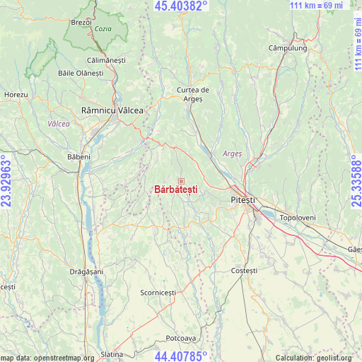
Bărbătești GPS coordinates[2]
44° 54' 28.764" North, 24° 37' 57.9" East
| Map corner | latitude | longitude |
|---|---|---|
| Upper-left | 45.40382°, | 23.92963° |
| Center: | 44.90799°, | 24.63275° |
| Lower-right: | 44.40785°, | 25.33588° |
| Map W x H: | 110.7×110.7 km | = 68.8×68.8mi |
| max Lat: | 48.23793° ⇑72.7% North |
| Bărbătești: | 44.90799° |
| min Lat: | ⇓27.3% South 43.65638° |
| min Long | Bărbătești | max Long |
| 20.31667° | 24.63275° | 29.65403° |
| W 41.5%⇐ | ⇒58.5% E |
Elevation
Elevation of Bărbătești is 363 m = 1191 ft, and this is 108.1 m = 355 ft above average elevation for this country.
| Max E: |
1278 m = 4193 ft | 23.7% |
| Bărbătești | 363 m 1191 ft | |
| Avg. | 254.9 m = 836 ft | |
Min E: |
-2 m = -7 ft | 76.3% |
See also: Romania elevation on elevation.city.
Geographical zone
Bărbătești is located in North temperate zone (between Tropic of Cancer and the Arctic Circle). Distance of this Northern Tropic circle is 2387.4 km =1483.5 mi to South.| Distance of | km | miles | from Bărbătești |
|---|---|---|---|
| North Pole | 5013.8 | 3115.4 | to North |
| Arctic Circle | 2407.9 | 1496.2 | to North |
| Tropic Cancer | 2387.4 | 1483.5 | to South |
| Equator | 4993.3 | 3102.7 | to South |


Nearby cities:
15 places around Bărbătești: (largest is in red/bold)
• Băbana
5.4 km =3.4 mi,  99°
99°
• Ciobănești
9.7 km =6 mi,  117°
117°
• Cocu
4.8 km =3 mi,  163°
163°
• Cotmeana
6.6 km =4.1 mi,  349°
349°
• Cuca
10.3 km =6.4 mi,  297°
297°
• Drăganu-Olteni
7.2 km =4.5 mi,  66°
66°
• Dumbrăvești
7.6 km =4.7 mi,  37°
37°
• Izvoru de Sus
10.2 km =6.3 mi,  172°
172°
• Merişani
11 km =6.8 mi,  52°
52°
• Mica
10.2 km =6.3 mi, 104°
• Prislopu Mare
8 km =5 mi,  93°
93°
• Răchițele de Jos
3.5 km =2.2 mi,  134°
134°
• Răchițele de Sus
1.6 km =1 mi, 99°
• Uda
5.3 km =3.3 mi,  280°
280°
• Valea Ursului
11.1 km =6.9 mi, 100°
Sources, notices
• [Note1] Compared only with cities in Romania existing in our database
• [Src1] Map data: © OpenStreetMap contributors (CC-BY-SA)
• [Src2] Other city data from geonames.org with taken over terms of usage.
• [Src3] Geographical zone / Annual Mean Temperature by Robert A. Rohde @ Wikipedia
