Ţuţora geodata
Ţuţora (Iaşi) is a seat of a second-order administrative division; located in Romania in Europe/Bucharest (GMT+3) time zone. With population of 2,126 people, there are 2489 cities with bigger population in this country. Compared to other cities in Romania, 82.2% of cities are located further ↓South; 94.1% of cities are located further ←West and 95.8% of cities have higher elevation than Ţuţora. Note1


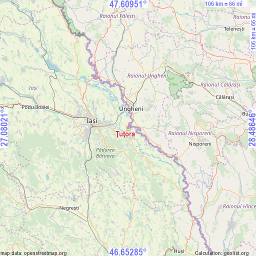
Ţuţora GPS coordinates[2]
47° 7' 59.988" North, 27° 46' 59.988" East
| Map corner | latitude | longitude |
|---|---|---|
| Upper-left | 47.60951°, | 27.08021° |
| Center: | 47.13333°, | 27.78333° |
| Lower-right: | 46.65285°, | 28.48646° |
| Map W x H: | 106.4×106.4 km | = 66.1×66.1mi |
| max Lat: | 48.23793° ⇑17.8% North |
| Ţuţora: | 47.13333° |
| min Lat: | ⇓82.2% South 43.65638° |
| min Long | Ţuţora | max Long |
| 20.31667° | 27.78333° | 29.65403° |
| W 94.1%⇐ | ⇒5.9% E |
Elevation
Elevation of Ţuţora is 31 m = 102 ft, and this is 223.9 m = 735 ft below average elevation for this country.
| Max E: |
1278 m = 4193 ft | 95.8% |
| Avg. | 254.9 m = 836 ft | |
| Ţuţora | 31 m = 102 ft | |
Min E: |
-2 m = -7 ft | 4.2% |
See also: Romania elevation on elevation.city.
Geographical zone
Ţuţora is located in North temperate zone (between Tropic of Cancer and the Arctic Circle). Distance of this North polar circle is 2160.4 km =1342.4 mi to North.| Distance of | km | miles | from Ţuţora |
|---|---|---|---|
| North Pole | 4766.3 | 2961.6 | to North |
| Arctic Circle | 2160.4 | 1342.4 | to North |
| Tropic Cancer | 2634.8 | 1637.2 | to South |
| Equator | 5240.7 | 3256.4 | to South |


Nearby cities:
15 places around Ţuţora: (largest is in red/bold)
• Bosia
9.4 km =5.8 mi,  352°
352°
• Chicerea
4.1 km =2.5 mi,  221°
221°
• Comarna
9.3 km =5.8 mi,  180°
180°
• Cristești
6.1 km =3.8 mi,  312°
312°
• Dancu
9.2 km =5.7 mi,  284°
284°
• Goruni
5.9 km =3.7 mi,  236°
236°
• Holboca
6.6 km =4.1 mi,  286°
286°
• Moreni
7.5 km =4.7 mi,  120°
120°
• Mânzătești
7.5 km =4.7 mi,  317°
317°
• Oprișeni
3.2 km =2 mi,  98°
98°
• Orzeni
8.7 km =5.4 mi, 308°
• Osoi
4.5 km =2.8 mi,  162°
162°
• Prisăcani
9.4 km =5.8 mi,  126°
126°
• Tomeşti
7.8 km =4.8 mi,  256°
256°
• Ungheni
7.4 km =4.6 mi,  0°
0°
Sources, notices
• [Note1] Compared only with cities in Romania existing in our database
• [Src1] Map data: © OpenStreetMap contributors (CC-BY-SA)
• [Src2] Other city data from geonames.org with taken over terms of usage.
• [Src3] Geographical zone / Annual Mean Temperature by Robert A. Rohde @ Wikipedia
