Holboca geodata
Holboca (Iaşi) is a seat of a second-order administrative division; located in Romania in Europe/Bucharest (GMT+3) time zone. With population of 11,708 people, there are 168 cities with bigger population in this country. Compared to other cities in Romania, 82.5% of cities are located further ↓South; 93.1% of cities are located further ←West and 91.3% of cities have higher elevation than Holboca. Note1


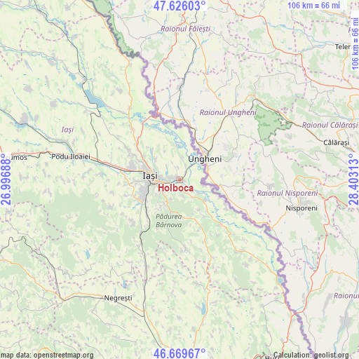
Holboca GPS coordinates[2]
47° 9' 0" North, 27° 42' 0" East
| Map corner | latitude | longitude |
|---|---|---|
| Upper-left | 47.62603°, | 26.99688° |
| Center: | 47.15°, | 27.7° |
| Lower-right: | 46.66967°, | 28.40313° |
| Map W x H: | 106.3×106.3 km | = 66.1×66.1mi |
| max Lat: | 48.23793° ⇑17.5% North |
| Holboca: | 47.15° |
| min Lat: | ⇓82.5% South 43.65638° |
| min Long | Holboca | max Long |
| 20.31667° | 27.7° | 29.65403° |
| W 93.1%⇐ | ⇒6.9% E |
Elevation
Elevation of Holboca is 52 m = 171 ft, and this is 202.9 m = 666 ft below average elevation for this country.
| Max E: |
1278 m = 4193 ft | 91.3% |
| Avg. | 254.9 m = 836 ft | |
| Holboca | 52 m = 171 ft | |
Min E: |
-2 m = -7 ft | 8.7% |
See also: Romania elevation on elevation.city.
Geographical zone
Holboca is located in North temperate zone (between Tropic of Cancer and the Arctic Circle). Distance of this North polar circle is 2158.6 km =1341.3 mi to North.| Distance of | km | miles | from Holboca |
|---|---|---|---|
| North Pole | 4764.5 | 2960.5 | to North |
| Arctic Circle | 2158.6 | 1341.3 | to North |
| Tropic Cancer | 2636.7 | 1638.4 | to South |
| Equator | 5242.6 | 3257.6 | to South |


Nearby cities:
15 places around Holboca: (largest is in red/bold)
• Aroneanu
9.4 km =5.8 mi,  306°
306°
• Bosia
9 km =5.6 mi,  34°
34°
• Chicerea
6.1 km =3.8 mi,  144°
144°
• Coada Stâncii
5.6 km =3.5 mi,  0°
0°
• Cristești
2.9 km =1.8 mi,  38°
38°
• Dancu
2.6 km =1.6 mi,  280°
280°
• Golăiești
9.3 km =5.8 mi, 0°
• Goruni
5.3 km =3.3 mi,  164°
164°
• Iaşi
7.8 km =4.8 mi, 283°
• Mânzătești
3.9 km =2.4 mi,  18°
18°
• Orzeni
3.6 km =2.2 mi,  352°
352°
• Păun
6.2 km =3.9 mi,  207°
207°
• Tomeşti
3.9 km =2.4 mi,  198°
198°
• Ungheni
8.4 km =5.2 mi,  48°
48°
• Ţuţora
6.6 km =4.1 mi,  106°
106°
Sources, notices
• [Note1] Compared only with cities in Romania existing in our database
• [Src1] Map data: © OpenStreetMap contributors (CC-BY-SA)
• [Src2] Other city data from geonames.org with taken over terms of usage.
• [Src3] Geographical zone / Annual Mean Temperature by Robert A. Rohde @ Wikipedia
