Suceveni geodata
Suceveni (Galaţi) is a seat of a second-order administrative division; located in Romania in Europe/Bucharest (GMT+3) time zone. With population of 2,160 people, there are 2461 cities with bigger population in this country. Compared to other cities in Romania, 55.3% of cities are located further ↓South; 96.4% of cities are located further ←West and 87.6% of cities have higher elevation than Suceveni. Note1


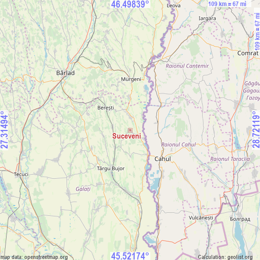
Suceveni GPS coordinates[2]
46° 0' 43.992" North, 28° 1' 5.016" East
| Map corner | latitude | longitude |
|---|---|---|
| Upper-left | 46.49839°, | 27.31494° |
| Center: | 46.01222°, | 28.01806° |
| Lower-right: | 45.52174°, | 28.72119° |
| Map W x H: | 108.6×108.6 km | = 67.5×67.5mi |
| max Lat: | 48.23793° ⇑44.7% North |
| Suceveni: | 46.01222° |
| min Lat: | ⇓55.3% South 43.65638° |
| min Long | Suceveni | max Long |
| 20.31667° | 28.01806° | 29.65403° |
| W 96.4%⇐ | ⇒3.6% E |
Elevation
Elevation of Suceveni is 69 m = 226 ft, and this is 185.9 m = 610 ft below average elevation for this country.
| Max E: |
1278 m = 4193 ft | 87.6% |
| Avg. | 254.9 m = 836 ft | |
| Suceveni | 69 m = 226 ft | |
Min E: |
-2 m = -7 ft | 12.4% |
See also: Romania elevation on elevation.city.
Geographical zone
Suceveni is located in North temperate zone (between Tropic of Cancer and the Arctic Circle). Distance of this North polar circle is 2285.1 km =1419.9 mi to North.| Distance of | km | miles | from Suceveni |
|---|---|---|---|
| North Pole | 4891 | 3039.1 | to North |
| Arctic Circle | 2285.1 | 1419.9 | to North |
| Tropic Cancer | 2510.2 | 1559.8 | to South |
| Equator | 5116.1 | 3179 | to South |


Nearby cities:
15 places around Suceveni: (largest is in red/bold)
• Balintești
7.7 km =4.8 mi,  284°
284°
• Bereşti-Sat
14.3 km =8.9 mi,  313°
313°
• Berești
14.3 km =8.9 mi, 313°
• Berești-Meria
12.1 km =7.5 mi, 312°
• Blăgeşti
13.9 km =8.6 mi,  358°
358°
• Băneasa
10.9 km =6.8 mi,  216°
216°
• Cavadineşti
6.1 km =3.8 mi, 359°
• Gănești
8.8 km =5.5 mi,  347°
347°
• Jorăşti
12.1 km =7.5 mi,  254°
254°
• Moscu
13.9 km =8.6 mi,  208°
208°
• Oancea
12.4 km =7.7 mi,  149°
149°
• Rogojeni
6.8 km =4.2 mi,  121°
121°
• Roșcani
11 km =6.8 mi,  177°
177°
• Slivna
10 km =6.2 mi,  323°
323°
• Vădeni
8 km =5 mi,  41°
41°
Sources, notices
• [Note1] Compared only with cities in Romania existing in our database
• [Src1] Map data: © OpenStreetMap contributors (CC-BY-SA)
• [Src2] Other city data from geonames.org with taken over terms of usage.
• [Src3] Geographical zone / Annual Mean Temperature by Robert A. Rohde @ Wikipedia
