Ţigăneşti geodata
Ţigăneşti (Teleorman) is a seat of a second-order administrative division; located in Romania in Europe/Bucharest (GMT+3) time zone. With population of 5,397 people, there are 664 cities with bigger population in this country. Compared to other cities in Romania, 98.5% of cities are located further ↑North; 52.2% of cities are located further ←West and 94.2% of cities have higher elevation than Ţigăneşti. Note1


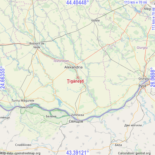
Ţigăneşti GPS coordinates[2]
43° 54' 0" North, 25° 22' 0.012" East
| Map corner | latitude | longitude |
|---|---|---|
| Upper-left | 44.40448°, | 24.66355° |
| Center: | 43.9°, | 25.36667° |
| Lower-right: | 43.39121°, | 26.0698° |
| Map W x H: | 112.7×112.7 km | = 70×70mi |
| max Lat: | 48.23793° ⇑98.5% North |
| Ţigăneşti: | 43.9° |
| min Lat: | ⇓1.5% South 43.65638° |
| min Long | Ţigăneşti | max Long |
| 20.31667° | 25.36667° | 29.65403° |
| W 52.2%⇐ | ⇒47.8% E |
Elevation
Elevation of Ţigăneşti is 38 m = 125 ft, and this is 216.9 m = 712 ft below average elevation for this country.
| Max E: |
1278 m = 4193 ft | 94.2% |
| Avg. | 254.9 m = 836 ft | |
| Ţigăneşti | 38 m = 125 ft | |
Min E: |
-2 m = -7 ft | 5.8% |
See also: Romania elevation on elevation.city.
Geographical zone
Ţigăneşti is located in North temperate zone (between Tropic of Cancer and the Arctic Circle). Distance of this Northern Tropic circle is 2275.3 km =1413.8 mi to South.| Distance of | km | miles | from Ţigăneşti |
|---|---|---|---|
| North Pole | 5125.8 | 3185 | to North |
| Arctic Circle | 2520 | 1565.9 | to North |
| Tropic Cancer | 2275.3 | 1413.8 | to South |
| Equator | 4881.2 | 3033 | to South |


Nearby cities:
15 places around Ţigăneşti: (largest is in red/bold)
• Alexandria
9.6 km =6 mi,  343°
343°
• Beiu
7.7 km =4.8 mi,  112°
112°
• Brânceni
3.3 km =2.1 mi,  124°
124°
• Calomfirești
2.1 km =1.3 mi, 340°
• Cernetu
7.3 km =4.5 mi,  83°
83°
• Cervenia
10.9 km =6.8 mi,  132°
132°
• Izvoarele
9.4 km =5.8 mi,  171°
171°
• Mârzăneşti
8.8 km =5.5 mi,  65°
65°
• Poroschia
3.7 km =2.3 mi,  0°
0°
• Purani
10.5 km =6.5 mi,  32°
32°
• Smârdioasa
7.7 km =4.8 mi,  136°
136°
• Storobăneasa
6.9 km =4.3 mi, 105°
• Teleormanu
10.1 km =6.3 mi,  46°
46°
• Valea Părului
8.2 km =5.1 mi, 76°
• Șoimu
9.7 km =6 mi, 140°
Sources, notices
• [Note1] Compared only with cities in Romania existing in our database
• [Src1] Map data: © OpenStreetMap contributors (CC-BY-SA)
• [Src2] Other city data from geonames.org with taken over terms of usage.
• [Src3] Geographical zone / Annual Mean Temperature by Robert A. Rohde @ Wikipedia
