Teleormanu geodata
Teleormanu (Teleorman) is a populated place; located in Romania in Europe/Bucharest (GMT+3) time zone. With population of 1,225 people, there are 3691 cities with bigger population in this country. Compared to other cities in Romania, 97.5% of cities are located further ↑North; 54.1% of cities are located further ←West and 91.3% of cities have higher elevation than Teleormanu. Note1


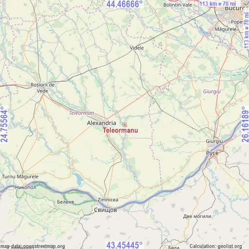
Teleormanu GPS coordinates[2]
43° 57' 45.756" North, 25° 27' 31.536" East
| Map corner | latitude | longitude |
|---|---|---|
| Upper-left | 44.46666°, | 24.75564° |
| Center: | 43.96271°, | 25.45876° |
| Lower-right: | 43.45445°, | 26.16189° |
| Map W x H: | 112.5×112.5 km | = 69.9×69.9mi |
| max Lat: | 48.23793° ⇑97.5% North |
| Teleormanu: | 43.96271° |
| min Lat: | ⇓2.5% South 43.65638° |
| min Long | Teleormanu | max Long |
| 20.31667° | 25.45876° | 29.65403° |
| W 54.1%⇐ | ⇒45.9% E |
Elevation
Elevation of Teleormanu is 52 m = 171 ft, and this is 202.9 m = 666 ft below average elevation for this country.
| Max E: |
1278 m = 4193 ft | 91.3% |
| Avg. | 254.9 m = 836 ft | |
| Teleormanu | 52 m = 171 ft | |
Min E: |
-2 m = -7 ft | 8.7% |
See also: Romania elevation on elevation.city.
Geographical zone
Teleormanu is located in North temperate zone (between Tropic of Cancer and the Arctic Circle). Distance of this Northern Tropic circle is 2282.3 km =1418.2 mi to South.| Distance of | km | miles | from Teleormanu |
|---|---|---|---|
| North Pole | 5118.9 | 3180.7 | to North |
| Arctic Circle | 2513 | 1561.5 | to North |
| Tropic Cancer | 2282.3 | 1418.2 | to South |
| Equator | 4888.2 | 3037.4 | to South |


Nearby cities:
15 places around Teleormanu: (largest is in red/bold)
• Beiu
9.9 km =6.2 mi,  181°
181°
• Brânceni
10 km =6.2 mi,  208°
208°
• Calomfirești
9.5 km =5.9 mi,  237°
237°
• Cernetu
6.2 km =3.9 mi, 181°
• Mârzăneşti
3.3 km =2.1 mi,  169°
169°
• Măgura
9.2 km =5.7 mi,  329°
329°
• Poroschia
8.1 km =5 mi,  246°
246°
• Purani
2.6 km =1.6 mi,  317°
317°
• Răsmireşti
7.7 km =4.8 mi,  72°
72°
• Schitu Poienari
3.3 km =2.1 mi,  27°
27°
• Siliștea
4.2 km =2.6 mi,  8°
8°
• Storobăneasa
8.9 km =5.5 mi, 184°
• Valea Părului
5.1 km =3.2 mi, 173°
• Vităneşti
5.3 km =3.3 mi, 320°
• Ţigăneşti
10.1 km =6.3 mi,  226°
226°
Sources, notices
• [Note1] Compared only with cities in Romania existing in our database
• [Src1] Map data: © OpenStreetMap contributors (CC-BY-SA)
• [Src2] Other city data from geonames.org with taken over terms of usage.
• [Src3] Geographical zone / Annual Mean Temperature by Robert A. Rohde @ Wikipedia
