Şugag geodata
Şugag (Alba) is a seat of a second-order administrative division; located in Romania in Europe/Bucharest (GMT+3) time zone. With population of 3,175 people, there are 1637 cities with bigger population in this country. Compared to other cities in Romania, 50.6% of cities are located further ↑North; 75.2% of cities are located further →East and 95.2% of cities have lower elevation than Şugag. Note1


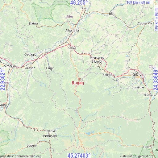
Şugag GPS coordinates[2]
45° 46' 0.012" North, 23° 37' 59.988" East
| Map corner | latitude | longitude |
|---|---|---|
| Upper-left | 46.255°, | 22.93021° |
| Center: | 45.76667°, | 23.63333° |
| Lower-right: | 45.27403°, | 24.33646° |
| Map W x H: | 109.1×109.1 km | = 67.8×67.8mi |
| max Lat: | 48.23793° ⇑50.6% North |
| Şugag: | 45.76667° |
| min Lat: | ⇓49.4% South 43.65638° |
| min Long | Şugag | max Long |
| 20.31667° | 23.63333° | 29.65403° |
| W 24.8%⇐ | ⇒75.2% E |
Elevation
Elevation of Şugag is 633 m = 2077 ft, and this is 378.1 m = 1240 ft above average elevation for this country.
| Max E: |
1278 m = 4193 ft | 4.8% |
| Şugag | 633 m 2077 ft | |
| Avg. | 254.9 m = 836 ft | |
Min E: |
-2 m = -7 ft | 95.2% |
See also: Romania elevation on elevation.city.
Geographical zone
Şugag is located in North temperate zone (between Tropic of Cancer and the Arctic Circle). Distance of this North polar circle is 2312.4 km =1436.9 mi to North.| Distance of | km | miles | from Şugag |
|---|---|---|---|
| North Pole | 4918.3 | 3056.1 | to North |
| Arctic Circle | 2312.4 | 1436.9 | to North |
| Tropic Cancer | 2482.9 | 1542.8 | to South |
| Equator | 5088.8 | 3162 | to South |


Nearby cities:
15 places around Şugag: (largest is in red/bold)
• Câlnic
13.2 km =8.2 mi,  11°
11°
• Căpâlna
9.1 km =5.7 mi,  345°
345°
• Deal
10.3 km =6.4 mi,  357°
357°
• Dobra
0.7 km =0.4 mi,  68°
68°
• Gârbova
13.6 km =8.5 mi,  34°
34°
• Jina
4.3 km =2.7 mi,  64°
64°
• Loman
11.9 km =7.4 mi,  328°
328°
• Mărtinie
3.5 km =2.2 mi, 327°
• Poiana Sibiului
8.6 km =5.3 mi, 64°
• Rod
12.4 km =7.7 mi, 72°
• Răchita
15.1 km =9.4 mi,  323°
323°
• Răhău
15.2 km =9.4 mi, 356°
• Sebeșel
14.4 km =8.9 mi,  338°
338°
• Săsciori
11.8 km =7.3 mi, 340°
• Tilişca
17.2 km =10.7 mi,  77°
77°
Sources, notices
• [Note1] Compared only with cities in Romania existing in our database
• [Src1] Map data: © OpenStreetMap contributors (CC-BY-SA)
• [Src2] Other city data from geonames.org with taken over terms of usage.
• [Src3] Geographical zone / Annual Mean Temperature by Robert A. Rohde @ Wikipedia
