Straja geodata
Straja (Neamţ) is a populated place; located in Romania in Europe/Bucharest (GMT+3) time zone. With population of 688 people, there are 5645 cities with bigger population in this country. Compared to other cities in Romania, 76.5% of cities are located further ↓South; 66.4% of cities are located further ←West and 77.9% of cities have lower elevation than Straja. Note1


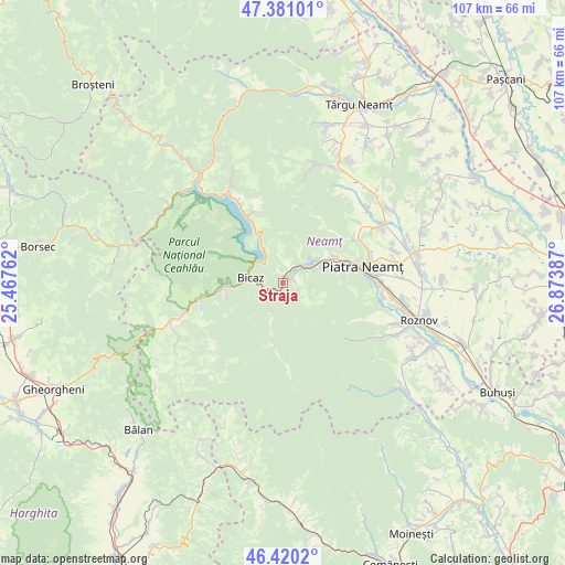
Straja GPS coordinates[2]
46° 54' 9.936" North, 26° 10' 14.664" East
| Map corner | latitude | longitude |
|---|---|---|
| Upper-left | 47.38101°, | 25.46762° |
| Center: | 46.90276°, | 26.17074° |
| Lower-right: | 46.4202°, | 26.87387° |
| Map W x H: | 106.8×106.8 km | = 66.4×66.4mi |
| max Lat: | 48.23793° ⇑23.5% North |
| Straja: | 46.90276° |
| min Lat: | ⇓76.5% South 43.65638° |
| min Long | Straja | max Long |
| 20.31667° | 26.17074° | 29.65403° |
| W 66.4%⇐ | ⇒33.6% E |
Elevation
Elevation of Straja is 375 m = 1230 ft, and this is 120.1 m = 394 ft above average elevation for this country.
| Max E: |
1278 m = 4193 ft | 22.1% |
| Straja | 375 m 1230 ft | |
| Avg. | 254.9 m = 836 ft | |
Min E: |
-2 m = -7 ft | 77.9% |
See also: Romania elevation on elevation.city.
Geographical zone
Straja is located in North temperate zone (between Tropic of Cancer and the Arctic Circle). Distance of this North polar circle is 2186.1 km =1358.4 mi to North.| Distance of | km | miles | from Straja |
|---|---|---|---|
| North Pole | 4792 | 2977.6 | to North |
| Arctic Circle | 2186.1 | 1358.4 | to North |
| Tropic Cancer | 2609.2 | 1621.3 | to South |
| Equator | 5215.1 | 3240.5 | to South |


Nearby cities:
15 places around Straja: (largest is in red/bold)
• Bicaz
8.1 km =5 mi,  281°
281°
• Bistrița
10.8 km =6.7 mi,  61°
61°
• Capșa
4.6 km =2.9 mi,  272°
272°
• Cazaci
5.4 km =3.4 mi,  202°
202°
• Dodeni
6.5 km =4 mi,  293°
293°
• Oanțu
2.3 km =1.4 mi,  70°
70°
• Piatra Neamţ
12.4 km =7.7 mi,  82°
82°
• Pângăraţi
3.7 km =2.3 mi,  335°
335°
• Pângărăcior
4.9 km =3 mi,  45°
45°
• Stejaru
1.9 km =1.2 mi,  21°
21°
• Tarcău
4.9 km =3 mi,  215°
215°
• Taşca
11.7 km =7.3 mi, 268°
• Vaduri
7.4 km =4.6 mi, 68°
• Viişoara
5.8 km =3.6 mi, 54°
• Vădurele
7 km =4.3 mi, 60°
Sources, notices
• [Note1] Compared only with cities in Romania existing in our database
• [Src1] Map data: © OpenStreetMap contributors (CC-BY-SA)
• [Src2] Other city data from geonames.org with taken over terms of usage.
• [Src3] Geographical zone / Annual Mean Temperature by Robert A. Rohde @ Wikipedia
