Cazaci geodata
Cazaci (Neamţ) is a populated place; located in Romania in Europe/Bucharest (GMT+3) time zone. With population of 518 people, there are 6881 cities with bigger population in this country. Compared to other cities in Romania, 75.5% of cities are located further ↓South; 65.8% of cities are located further ←West and 83.8% of cities have lower elevation than Cazaci. Note1


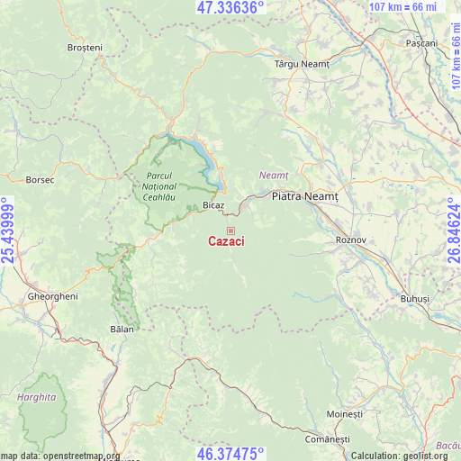
Cazaci GPS coordinates[2]
46° 51' 27.756" North, 26° 8' 35.196" East
| Map corner | latitude | longitude |
|---|---|---|
| Upper-left | 47.33636°, | 25.43999° |
| Center: | 46.85771°, | 26.14311° |
| Lower-right: | 46.37475°, | 26.84624° |
| Map W x H: | 106.9×106.9 km | = 66.4×66.4mi |
| max Lat: | 48.23793° ⇑24.5% North |
| Cazaci: | 46.85771° |
| min Lat: | ⇓75.5% South 43.65638° |
| min Long | Cazaci | max Long |
| 20.31667° | 26.14311° | 29.65403° |
| W 65.8%⇐ | ⇒34.2% E |
Elevation
Elevation of Cazaci is 432 m = 1417 ft, and this is 177.1 m = 581 ft above average elevation for this country.
| Max E: |
1278 m = 4193 ft | 16.2% |
| Cazaci | 432 m 1417 ft | |
| Avg. | 254.9 m = 836 ft | |
Min E: |
-2 m = -7 ft | 83.8% |
See also: Romania elevation on elevation.city.
Geographical zone
Cazaci is located in North temperate zone (between Tropic of Cancer and the Arctic Circle). Distance of this North polar circle is 2191.1 km =1361.5 mi to North.| Distance of | km | miles | from Cazaci |
|---|---|---|---|
| North Pole | 4797 | 2980.7 | to North |
| Arctic Circle | 2191.1 | 1361.5 | to North |
| Tropic Cancer | 2604.2 | 1618.2 | to South |
| Equator | 5210.1 | 3237.4 | to South |


Nearby cities:
15 places around Cazaci: (largest is in red/bold)
• Bicaz
8.8 km =5.5 mi,  318°
318°
• Bistrița
15.4 km =9.6 mi,  48°
48°
• Capșa
5.8 km =3.6 mi,  334°
334°
• Dodeni
8.5 km =5.3 mi, 333°
• Neagra
12.3 km =7.6 mi,  281°
281°
• Oanțu
7.2 km =4.5 mi,  36°
36°
• Pângăraţi
8.4 km =5.2 mi,  3°
3°
• Pângărăcior
10.1 km =6.3 mi,  33°
33°
• Stejaru
7.4 km =4.6 mi,  22°
22°
• Straja
5.4 km =3.4 mi, 22°
• Tarcău
1.2 km =0.7 mi, 323°
• Taşca
10.7 km =6.6 mi,  296°
296°
• Vaduri
11.9 km =7.4 mi, 49°
• Viişoara
10.8 km =6.7 mi, 39°
• Vădurele
11.7 km =7.3 mi, 44°
Sources, notices
• [Note1] Compared only with cities in Romania existing in our database
• [Src1] Map data: © OpenStreetMap contributors (CC-BY-SA)
• [Src2] Other city data from geonames.org with taken over terms of usage.
• [Src3] Geographical zone / Annual Mean Temperature by Robert A. Rohde @ Wikipedia
