Stoina geodata
Stoina (Gorj) is a seat of a second-order administrative division; located in Romania in Europe/Bucharest (GMT+3) time zone. With population of 2,791 people, there are 1917 cities with bigger population in this country. Compared to other cities in Romania, 80.6% of cities are located further ↑North; 75.2% of cities are located further →East and 54.8% of cities have higher elevation than Stoina. Note1


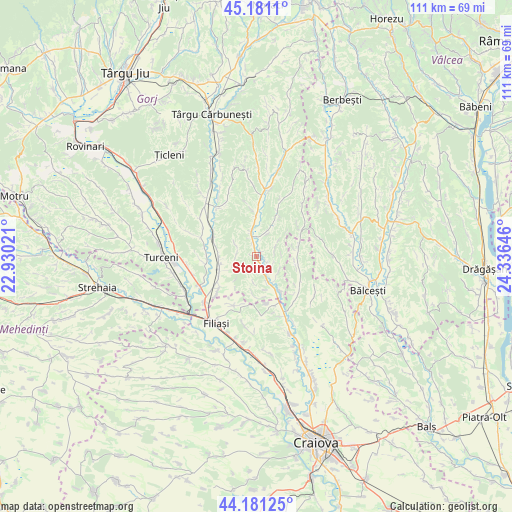
Stoina GPS coordinates[2]
44° 40' 59.988" North, 23° 37' 59.988" East
| Map corner | latitude | longitude |
|---|---|---|
| Upper-left | 45.1811°, | 22.93021° |
| Center: | 44.68333°, | 23.63333° |
| Lower-right: | 44.18125°, | 24.33646° |
| Map W x H: | 111.2×111.2 km | = 69.1×69.1mi |
| max Lat: | 48.23793° ⇑80.6% North |
| Stoina: | 44.68333° |
| min Lat: | ⇓19.4% South 43.65638° |
| min Long | Stoina | max Long |
| 20.31667° | 23.63333° | 29.65403° |
| W 24.8%⇐ | ⇒75.2% E |
Elevation
Elevation of Stoina is 188 m = 617 ft, and this is 66.9 m = 219 ft below average elevation for this country.
| Max E: |
1278 m = 4193 ft | 54.8% |
| Avg. | 254.9 m = 836 ft | |
| Stoina | 188 m = 617 ft | |
Min E: |
-2 m = -7 ft | 45.2% |
See also: Romania elevation on elevation.city.
Geographical zone
Stoina is located in North temperate zone (between Tropic of Cancer and the Arctic Circle). Distance of this Northern Tropic circle is 2362.4 km =1467.9 mi to South.| Distance of | km | miles | from Stoina |
|---|---|---|---|
| North Pole | 5038.7 | 3130.9 | to North |
| Arctic Circle | 2432.9 | 1511.7 | to North |
| Tropic Cancer | 2362.4 | 1467.9 | to South |
| Equator | 4968.3 | 3087.2 | to South |


Nearby cities:
15 places around Stoina: (largest is in red/bold)
• Baloșani
5.7 km =3.5 mi,  20°
20°
• Bulbuceni
5 km =3.1 mi,  297°
297°
• Cocorova
6.7 km =4.2 mi,  243°
243°
• Crușeț
6.2 km =3.9 mi,  154°
154°
• Căpreni
7.5 km =4.7 mi,  349°
349°
• Dănciuleşti
10.8 km =6.7 mi,  58°
58°
• Florești
10.9 km =6.8 mi,  229°
229°
• Golumbu
11 km =6.8 mi,  119°
119°
• Măiag
8 km =5 mi,  186°
186°
• Poiana
8.8 km =5.5 mi,  246°
246°
• Slăvuța
4.3 km =2.7 mi,  66°
66°
• Stejari
10.1 km =6.3 mi, 23°
• Turburea
9.9 km =6.2 mi,  291°
291°
• Tălpaș
8.9 km =5.5 mi,  90°
90°
• Șipotu
8.9 km =5.5 mi,  283°
283°
Sources, notices
• [Note1] Compared only with cities in Romania existing in our database
• [Src1] Map data: © OpenStreetMap contributors (CC-BY-SA)
• [Src2] Other city data from geonames.org with taken over terms of usage.
• [Src3] Geographical zone / Annual Mean Temperature by Robert A. Rohde @ Wikipedia
