Tălpaș geodata
Tălpaș (Dolj) is a seat of a second-order administrative division; located in Romania in Europe/Bucharest (GMT+3) time zone. With population of 308 people, there are 7053 cities with bigger population in this country. Compared to other cities in Romania, 80.6% of cities are located further ↑North; 73.5% of cities are located further →East and 52.2% of cities have lower elevation than Tălpaș. Note1


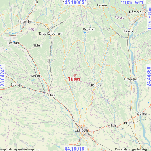
Tălpaș GPS coordinates[2]
44° 40' 56.172" North, 23° 44' 43.908" East
| Map corner | latitude | longitude |
|---|---|---|
| Upper-left | 45.18005°, | 23.04241° |
| Center: | 44.68227°, | 23.74553° |
| Lower-right: | 44.18018°, | 24.44866° |
| Map W x H: | 111.2×111.2 km | = 69.1×69.1mi |
| max Lat: | 48.23793° ⇑80.6% North |
| Tălpaș: | 44.68227° |
| min Lat: | ⇓19.4% South 43.65638° |
| min Long | Tălpaș | max Long |
| 20.31667° | 23.74553° | 29.65403° |
| W 26.5%⇐ | ⇒73.5% E |
Elevation
Elevation of Tălpaș is 223 m = 732 ft, and this is 31.9 m = 105 ft below average elevation for this country.
| Max E: |
1278 m = 4193 ft | 47.8% |
| Avg. | 254.9 m = 836 ft | |
| Tălpaș | 223 m = 732 ft | |
Min E: |
-2 m = -7 ft | 52.2% |
See also: Romania elevation on elevation.city.
Geographical zone
Tălpaș is located in North temperate zone (between Tropic of Cancer and the Arctic Circle). Distance of this Northern Tropic circle is 2362.3 km =1467.9 mi to South.| Distance of | km | miles | from Tălpaș |
|---|---|---|---|
| North Pole | 5038.9 | 3131 | to North |
| Arctic Circle | 2433 | 1511.8 | to North |
| Tropic Cancer | 2362.3 | 1467.9 | to South |
| Equator | 4968.2 | 3087.1 | to South |


Nearby cities:
15 places around Tălpaș: (largest is in red/bold)
• Amărăști
10.8 km =6.7 mi,  187°
187°
• Baloșani
8.7 km =5.4 mi,  308°
308°
• Crușeț
8.3 km =5.2 mi,  228°
228°
• Dănciuleşti
5.7 km =3.5 mi,  3°
3°
• Fărcaș
9.2 km =5.7 mi,  177°
177°
• Ghioroiu
7.2 km =4.5 mi,  74°
74°
• Golumbu
5.4 km =3.4 mi,  172°
172°
• Lăcusteni
12.3 km =7.6 mi,  83°
83°
• Măiag
12.5 km =7.8 mi, 231°
• Rădinești
12.2 km =7.6 mi,  7°
7°
• Slăvuța
5.2 km =3.2 mi,  290°
290°
• Stejari
10.6 km =6.6 mi,  332°
332°
• Stoina
8.9 km =5.5 mi,  270°
270°
• Velesti
9.7 km =6 mi,  159°
159°
• Zătreni
12.5 km =7.8 mi,  41°
41°
Sources, notices
• [Note1] Compared only with cities in Romania existing in our database
• [Src1] Map data: © OpenStreetMap contributors (CC-BY-SA)
• [Src2] Other city data from geonames.org with taken over terms of usage.
• [Src3] Geographical zone / Annual Mean Temperature by Robert A. Rohde @ Wikipedia
