Stoeneşti geodata
Stoeneşti (Vâlcea) is a seat of a second-order administrative division; located in Romania in Europe/Bucharest (GMT+3) time zone. With population of 3,863 people, there are 1222 cities with bigger population in this country. Compared to other cities in Romania, 64.9% of cities are located further ↑North; 66.6% of cities are located further →East and 68.1% of cities have lower elevation than Stoeneşti. Note1


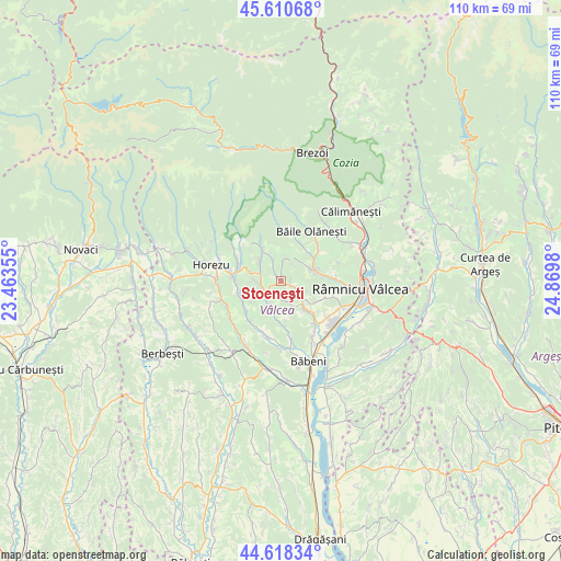
Stoeneşti GPS coordinates[2]
45° 7' 0.012" North, 24° 10' 0.012" East
| Map corner | latitude | longitude |
|---|---|---|
| Upper-left | 45.61068°, | 23.46355° |
| Center: | 45.11667°, | 24.16667° |
| Lower-right: | 44.61834°, | 24.8698° |
| Map W x H: | 110.3×110.3 km | = 68.5×68.5mi |
| max Lat: | 48.23793° ⇑64.9% North |
| Stoeneşti: | 45.11667° |
| min Lat: | ⇓35.1% South 43.65638° |
| min Long | Stoeneşti | max Long |
| 20.31667° | 24.16667° | 29.65403° |
| W 33.4%⇐ | ⇒66.6% E |
Elevation
Elevation of Stoeneşti is 307 m = 1007 ft, and this is 52.1 m = 171 ft above average elevation for this country.
| Max E: |
1278 m = 4193 ft | 31.9% |
| Stoeneşti | 307 m 1007 ft | |
| Avg. | 254.9 m = 836 ft | |
Min E: |
-2 m = -7 ft | 68.1% |
See also: Romania elevation on elevation.city.
Geographical zone
Stoeneşti is located in North temperate zone (between Tropic of Cancer and the Arctic Circle). Distance of this North polar circle is 2384.7 km =1481.8 mi to North.| Distance of | km | miles | from Stoeneşti |
|---|---|---|---|
| North Pole | 4990.6 | 3101 | to North |
| Arctic Circle | 2384.7 | 1481.8 | to North |
| Tropic Cancer | 2410.6 | 1497.9 | to South |
| Equator | 5016.5 | 3117.1 | to South |


Nearby cities:
15 places around Stoeneşti: (largest is in red/bold)
• Bodești
4.9 km =3 mi,  304°
304°
• Buneşti
1.3 km =0.8 mi,  90°
90°
• Băile Govora
3.9 km =2.4 mi,  160°
160°
• Coasta
6.1 km =3.8 mi,  70°
70°
• Gurișoara
6.2 km =3.9 mi,  136°
136°
• Lunca
8.3 km =5.2 mi,  105°
105°
• Negrulești
6.3 km =3.9 mi,  284°
284°
• Pietrari
3.2 km =2 mi,  234°
234°
• Pietrarii de Sus
5.8 km =3.6 mi,  270°
270°
• Prajila
3.8 km =2.4 mi,  176°
176°
• Păuşeşti
5.4 km =3.4 mi,  207°
207°
• Păuşeşti-Măglaşi
6.8 km =4.2 mi, 74°
• Teiușu
6.3 km =3.9 mi, 114°
• Valea Cheii
7.8 km =4.8 mi,  55°
55°
• Vlăduceni
7 km =4.3 mi, 71°
Sources, notices
• [Note1] Compared only with cities in Romania existing in our database
• [Src1] Map data: © OpenStreetMap contributors (CC-BY-SA)
• [Src2] Other city data from geonames.org with taken over terms of usage.
• [Src3] Geographical zone / Annual Mean Temperature by Robert A. Rohde @ Wikipedia
