Stâlpu geodata
Stâlpu (Buzău) is a seat of a second-order administrative division; located in Romania in Europe/Bucharest (GMT+3) time zone. With population of 3,175 people, there are 1637 cities with bigger population in this country. Compared to other cities in Romania, 66.4% of cities are located further ↑North; 76.9% of cities are located further ←West and 83.1% of cities have higher elevation than Stâlpu. Note1


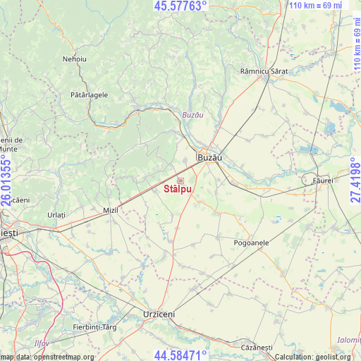
Stâlpu GPS coordinates[2]
45° 4' 59.988" North, 26° 43' 0.012" East
| Map corner | latitude | longitude |
|---|---|---|
| Upper-left | 45.57763°, | 26.01355° |
| Center: | 45.08333°, | 26.71667° |
| Lower-right: | 44.58471°, | 27.4198° |
| Map W x H: | 110.4×110.4 km | = 68.6×68.6mi |
| max Lat: | 48.23793° ⇑66.4% North |
| Stâlpu: | 45.08333° |
| min Lat: | ⇓33.6% South 43.65638° |
| min Long | Stâlpu | max Long |
| 20.31667° | 26.71667° | 29.65403° |
| W 76.9%⇐ | ⇒23.1% E |
Elevation
Elevation of Stâlpu is 84 m = 276 ft, and this is 170.9 m = 561 ft below average elevation for this country.
| Max E: |
1278 m = 4193 ft | 83.1% |
| Avg. | 254.9 m = 836 ft | |
| Stâlpu | 84 m = 276 ft | |
Min E: |
-2 m = -7 ft | 16.9% |
See also: Romania elevation on elevation.city.
Geographical zone
Stâlpu is located in North temperate zone (between Tropic of Cancer and the Arctic Circle). Distance of this North polar circle is 2388.4 km =1484.1 mi to North.| Distance of | km | miles | from Stâlpu |
|---|---|---|---|
| North Pole | 4994.3 | 3103.3 | to North |
| Arctic Circle | 2388.4 | 1484.1 | to North |
| Tropic Cancer | 2406.9 | 1495.6 | to South |
| Equator | 5012.8 | 3114.8 | to South |


Nearby cities:
15 places around Stâlpu: (largest is in red/bold)
• Budișteni
7 km =4.3 mi,  129°
129°
• Băltăreți
7.8 km =4.8 mi,  251°
251°
• Clondiru
8.6 km =5.3 mi, 247°
• Costeşti
5.4 km =3.4 mi, 133°
• Dealul Viei
5.9 km =3.7 mi,  304°
304°
• Gherăseni
8.7 km =5.4 mi,  137°
137°
• Izvoru Dulce
7.3 km =4.5 mi, 295°
• Lipia
6.4 km =4 mi,  12°
12°
• Merei
6.1 km =3.8 mi,  334°
334°
• Ogrăzile
4.7 km =2.9 mi,  322°
322°
• Pietrosu
4.2 km =2.6 mi, 129°
• Spătaru
4.9 km =3 mi,  87°
87°
• Sărata-Monteoru
9.4 km =5.8 mi, 321°
• Ulmeni
5.6 km =3.5 mi, 250°
• Vâlcele
6.5 km =4 mi,  273°
273°
Sources, notices
• [Note1] Compared only with cities in Romania existing in our database
• [Src1] Map data: © OpenStreetMap contributors (CC-BY-SA)
• [Src2] Other city data from geonames.org with taken over terms of usage.
• [Src3] Geographical zone / Annual Mean Temperature by Robert A. Rohde @ Wikipedia
