Gherăseni geodata
Gherăseni (Buzău) is a seat of a second-order administrative division; located in Romania in Europe/Bucharest (GMT+3) time zone. With population of 3,243 people, there are 1591 cities with bigger population in this country. Compared to other cities in Romania, 68.8% of cities are located further ↑North; 78.6% of cities are located further ←West and 84.7% of cities have higher elevation than Gherăseni. Note1


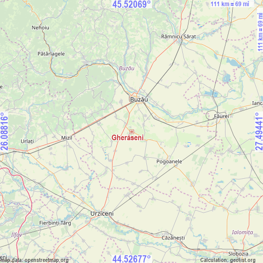
Gherăseni GPS coordinates[2]
45° 1' 33.204" North, 26° 47' 28.608" East
| Map corner | latitude | longitude |
|---|---|---|
| Upper-left | 45.52069°, | 26.08816° |
| Center: | 45.02589°, | 26.79128° |
| Lower-right: | 44.52677°, | 27.49441° |
| Map W x H: | 110.5×110.5 km | = 68.7×68.7mi |
| max Lat: | 48.23793° ⇑68.8% North |
| Gherăseni: | 45.02589° |
| min Lat: | ⇓31.2% South 43.65638° |
| min Long | Gherăseni | max Long |
| 20.31667° | 26.79128° | 29.65403° |
| W 78.6%⇐ | ⇒21.4% E |
Elevation
Elevation of Gherăseni is 79 m = 259 ft, and this is 175.9 m = 577 ft below average elevation for this country.
| Max E: |
1278 m = 4193 ft | 84.7% |
| Avg. | 254.9 m = 836 ft | |
| Gherăseni | 79 m = 259 ft | |
Min E: |
-2 m = -7 ft | 15.3% |
See also: Romania elevation on elevation.city.
Geographical zone
Gherăseni is located in North temperate zone (between Tropic of Cancer and the Arctic Circle). Distance of this North polar circle is 2394.8 km =1488.1 mi to North.| Distance of | km | miles | from Gherăseni |
|---|---|---|---|
| North Pole | 5000.7 | 3107.3 | to North |
| Arctic Circle | 2394.8 | 1488.1 | to North |
| Tropic Cancer | 2400.5 | 1491.6 | to South |
| Equator | 5006.4 | 3110.8 | to South |


Nearby cities:
15 places around Gherăseni: (largest is in red/bold)
• Albești
11.3 km =7 mi,  110°
110°
• Brădeanu
11.3 km =7 mi,  155°
155°
• Budișteni
2 km =1.2 mi,  347°
347°
• Costeşti
3.3 km =2.1 mi,  324°
324°
• Gălbinaşi
11.7 km =7.3 mi,  57°
57°
• Limpeziș
10.5 km =6.5 mi,  220°
220°
• Maxenu
5.8 km =3.6 mi, 60°
• Movila Banului
9.7 km =6 mi,  240°
240°
• Pietrosu
4.5 km =2.8 mi,  325°
325°
• Pogonele
8.9 km =5.5 mi,  40°
40°
• Smeeni
6.6 km =4.1 mi,  135°
135°
• Spătaru
6.7 km =4.2 mi, 351°
• Stâlpu
8.7 km =5.4 mi, 317°
• Sudiți
1.5 km =0.9 mi,  102°
102°
• Ţinteşti
7.5 km =4.7 mi,  52°
52°
Sources, notices
• [Note1] Compared only with cities in Romania existing in our database
• [Src1] Map data: © OpenStreetMap contributors (CC-BY-SA)
• [Src2] Other city data from geonames.org with taken over terms of usage.
• [Src3] Geographical zone / Annual Mean Temperature by Robert A. Rohde @ Wikipedia
