Stejaru geodata
Stejaru (Neamţ) is a populated place; located in Romania in Europe/Bucharest (GMT+3) time zone. With population of 752 people, there are 5275 cities with bigger population in this country. Compared to other cities in Romania, 82.8% of cities are located further ↓South; 59.7% of cities are located further ←West and 92.7% of cities have lower elevation than Stejaru. Note1


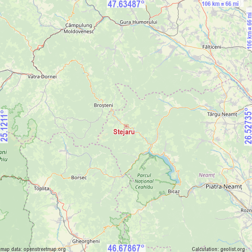
Stejaru GPS coordinates[2]
47° 9' 32.112" North, 25° 49' 27.192" East
| Map corner | latitude | longitude |
|---|---|---|
| Upper-left | 47.63487°, | 25.1211° |
| Center: | 47.15892°, | 25.82422° |
| Lower-right: | 46.67867°, | 26.52735° |
| Map W x H: | 106.3×106.3 km | = 66.1×66.1mi |
| max Lat: | 48.23793° ⇑17.2% North |
| Stejaru: | 47.15892° |
| min Lat: | ⇓82.8% South 43.65638° |
| min Long | Stejaru | max Long |
| 20.31667° | 25.82422° | 29.65403° |
| W 59.7%⇐ | ⇒40.3% E |
Elevation
Elevation of Stejaru is 563 m = 1847 ft, and this is 308.1 m = 1011 ft above average elevation for this country.
| Max E: |
1278 m = 4193 ft | 7.3% |
| Stejaru | 563 m 1847 ft | |
| Avg. | 254.9 m = 836 ft | |
Min E: |
-2 m = -7 ft | 92.7% |
See also: Romania elevation on elevation.city.
Geographical zone
Stejaru is located in North temperate zone (between Tropic of Cancer and the Arctic Circle). Distance of this North polar circle is 2157.6 km =1340.7 mi to North.| Distance of | km | miles | from Stejaru |
|---|---|---|---|
| North Pole | 4763.5 | 2959.9 | to North |
| Arctic Circle | 2157.6 | 1340.7 | to North |
| Tropic Cancer | 2637.7 | 1639 | to South |
| Equator | 5243.6 | 3258.2 | to South |


Nearby cities:
15 places around Stejaru: (largest is in red/bold)
• Borca
5.1 km =3.2 mi,  301°
301°
• Broşteni
12.5 km =7.8 mi,  311°
311°
• Dreptu
4.7 km =2.9 mi,  138°
138°
• Fărcaşa
1.1 km =0.7 mi,  38°
38°
• Grinţieş
12.5 km =7.8 mi,  165°
165°
• Mădei
7.4 km =4.6 mi, 313°
• Neagra
12.8 km =8 mi, 312°
• Petru Vodă
14.1 km =8.8 mi,  108°
108°
• Poiana Largului
13.6 km =8.5 mi,  121°
121°
• Poiana Teiului
12.6 km =7.8 mi, 121°
• Popești
3.6 km =2.2 mi,  104°
104°
• Pârâul Cârjei
6.3 km =3.9 mi,  316°
316°
• Pârâul Pântei
1 km =0.6 mi,  326°
326°
• Sabasa
4.8 km =3 mi,  354°
354°
• Soci
2.8 km =1.7 mi, 297°
Sources, notices
• [Note1] Compared only with cities in Romania existing in our database
• [Src1] Map data: © OpenStreetMap contributors (CC-BY-SA)
• [Src2] Other city data from geonames.org with taken over terms of usage.
• [Src3] Geographical zone / Annual Mean Temperature by Robert A. Rohde @ Wikipedia
