Grinţieş geodata
Grinţieş (Neamţ) is a seat of a second-order administrative division; located in Romania in Europe/Bucharest (GMT+3) time zone. With population of 2,573 people, there are 2100 cities with bigger population in this country. Compared to other cities in Romania, 80.2% of cities are located further ↓South; 60.5% of cities are located further ←West and 97.1% of cities have lower elevation than Grinţieş. Note1


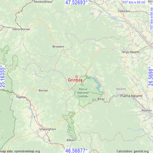
Grinţieş GPS coordinates[2]
47° 3' 0" North, 25° 52' 0.012" East
| Map corner | latitude | longitude |
|---|---|---|
| Upper-left | 47.52693°, | 25.16355° |
| Center: | 47.05°, | 25.86667° |
| Lower-right: | 46.56877°, | 26.5698° |
| Map W x H: | 106.5×106.5 km | = 66.2×66.2mi |
| max Lat: | 48.23793° ⇑19.8% North |
| Grinţieş: | 47.05° |
| min Lat: | ⇓80.2% South 43.65638° |
| min Long | Grinţieş | max Long |
| 20.31667° | 25.86667° | 29.65403° |
| W 60.5%⇐ | ⇒39.5% E |
Elevation
Elevation of Grinţieş is 723 m = 2372 ft, and this is 468.1 m = 1536 ft above average elevation for this country.
| Max E: |
1278 m = 4193 ft | 2.9% |
| Grinţieş | 723 m 2372 ft | |
| Avg. | 254.9 m = 836 ft | |
Min E: |
-2 m = -7 ft | 97.1% |
See also: Romania elevation on elevation.city.
Geographical zone
Grinţieş is located in North temperate zone (between Tropic of Cancer and the Arctic Circle). Distance of this North polar circle is 2169.7 km =1348.2 mi to North.| Distance of | km | miles | from Grinţieş |
|---|---|---|---|
| North Pole | 4775.6 | 2967.4 | to North |
| Arctic Circle | 2169.7 | 1348.2 | to North |
| Tropic Cancer | 2625.6 | 1631.5 | to South |
| Equator | 5231.5 | 3250.7 | to South |


Nearby cities:
15 places around Grinţieş: (largest is in red/bold)
• Bistricioara
4.7 km =2.9 mi,  85°
85°
• Bradu
5 km =3.1 mi,  190°
190°
• Ceahlău
7.6 km =4.7 mi, 90°
• Dreptu
8.6 km =5.3 mi,  359°
359°
• Fărcaşa
13.2 km =8.2 mi,  348°
348°
• Hangu
12.6 km =7.8 mi, 90°
• Petru Vodă
12.8 km =8 mi,  52°
52°
• Poiana
2.5 km =1.6 mi,  156°
156°
• Poiana Largului
9.8 km =6.1 mi,  59°
59°
• Poiana Teiului
9.4 km =5.8 mi, 53°
• Popești
11.2 km =7 mi,  1°
1°
• Pârâul Pântei
13.5 km =8.4 mi,  343°
343°
• Soci
14.5 km =9 mi, 336°
• Stejaru
12.5 km =7.8 mi, 345°
• Tulgheş
13.5 km =8.4 mi,  214°
214°
Sources, notices
• [Note1] Compared only with cities in Romania existing in our database
• [Src1] Map data: © OpenStreetMap contributors (CC-BY-SA)
• [Src2] Other city data from geonames.org with taken over terms of usage.
• [Src3] Geographical zone / Annual Mean Temperature by Robert A. Rohde @ Wikipedia
