Spermezeu geodata
Spermezeu (Bistriţa-Năsăud) is a seat of a second-order administrative division; located in Romania in Europe/Bucharest (GMT+3) time zone. With population of 2,573 people, there are 2100 cities with bigger population in this country. Compared to other cities in Romania, 86.5% of cities are located further ↓South; 67% of cities are located further →East and 72.3% of cities have lower elevation than Spermezeu. Note1


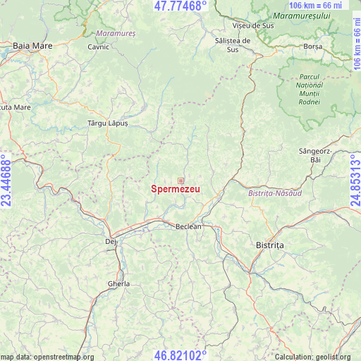
Spermezeu GPS coordinates[2]
47° 18' 0" North, 24° 9' 0" East
| Map corner | latitude | longitude |
|---|---|---|
| Upper-left | 47.77468°, | 23.44688° |
| Center: | 47.3°, | 24.15° |
| Lower-right: | 46.82102°, | 24.85313° |
| Map W x H: | 106×106 km | = 65.9×65.9mi |
| max Lat: | 48.23793° ⇑13.5% North |
| Spermezeu: | 47.3° |
| min Lat: | ⇓86.5% South 43.65638° |
| min Long | Spermezeu | max Long |
| 20.31667° | 24.15° | 29.65403° |
| W 33%⇐ | ⇒67% E |
Elevation
Elevation of Spermezeu is 336 m = 1102 ft, and this is 81.1 m = 266 ft above average elevation for this country.
| Max E: |
1278 m = 4193 ft | 27.7% |
| Spermezeu | 336 m 1102 ft | |
| Avg. | 254.9 m = 836 ft | |
Min E: |
-2 m = -7 ft | 72.3% |
See also: Romania elevation on elevation.city.
Geographical zone
Spermezeu is located in North temperate zone (between Tropic of Cancer and the Arctic Circle). Distance of this North polar circle is 2141.9 km =1330.9 mi to North.| Distance of | km | miles | from Spermezeu |
|---|---|---|---|
| North Pole | 4747.8 | 2950.1 | to North |
| Arctic Circle | 2141.9 | 1330.9 | to North |
| Tropic Cancer | 2653.3 | 1648.7 | to South |
| Equator | 5259.3 | 3268 | to South |


Nearby cities:
15 places around Spermezeu: (largest is in red/bold)
• Borleasa
5.5 km =3.4 mi,  21°
21°
• Breaza
8.7 km =5.4 mi,  310°
310°
• Chiuza
10.6 km =6.6 mi,  134°
134°
• Ciceu-Poieni
4.6 km =2.9 mi,  270°
270°
• Căianu Mare
7.6 km =4.7 mi,  172°
172°
• Căianu Mic
7.4 km =4.6 mi,  180°
180°
• Dobric
6.1 km =3.8 mi,  195°
195°
• Dobricel
2.8 km =1.7 mi,  262°
262°
• Dumbrăvița
5.4 km =3.4 mi,  150°
150°
• Ilișua
10.1 km =6.3 mi,  206°
206°
• Negrilești
8.3 km =5.2 mi,  246°
246°
• Perișor
6 km =3.7 mi,  74°
74°
• Piatra
10.4 km =6.5 mi,  123°
123°
• Răpănaşu
9.6 km =6 mi, 15°
• Târlişua
9.6 km =6 mi, 15°
Sources, notices
• [Note1] Compared only with cities in Romania existing in our database
• [Src1] Map data: © OpenStreetMap contributors (CC-BY-SA)
• [Src2] Other city data from geonames.org with taken over terms of usage.
• [Src3] Geographical zone / Annual Mean Temperature by Robert A. Rohde @ Wikipedia
