Slătinița geodata
Slătinița (Bistriţa-Năsăud) is a populated place; located in Romania in Europe/Bucharest (GMT+3) time zone. With population of 609 people, there are 6139 cities with bigger population in this country. Compared to other cities in Romania, 84.2% of cities are located further ↓South; 60% of cities are located further →East and 84.5% of cities have lower elevation than Slătinița. Note1


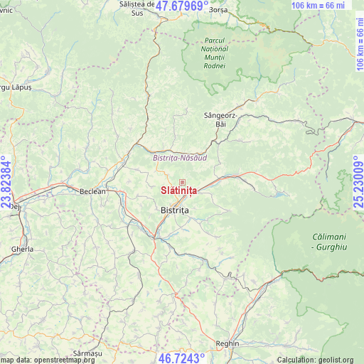
Slătinița GPS coordinates[2]
47° 12' 14.94" North, 24° 31' 37.056" East
| Map corner | latitude | longitude |
|---|---|---|
| Upper-left | 47.67969°, | 23.82384° |
| Center: | 47.20415°, | 24.52696° |
| Lower-right: | 46.7243°, | 25.23009° |
| Map W x H: | 106.2×106.2 km | = 66×66mi |
| max Lat: | 48.23793° ⇑15.8% North |
| Slătinița: | 47.20415° |
| min Lat: | ⇓84.2% South 43.65638° |
| min Long | Slătinița | max Long |
| 20.31667° | 24.52696° | 29.65403° |
| W 40%⇐ | ⇒60% E |
Elevation
Elevation of Slătinița is 440 m = 1444 ft, and this is 185.1 m = 607 ft above average elevation for this country.
| Max E: |
1278 m = 4193 ft | 15.5% |
| Slătinița | 440 m 1444 ft | |
| Avg. | 254.9 m = 836 ft | |
Min E: |
-2 m = -7 ft | 84.5% |
See also: Romania elevation on elevation.city.
Geographical zone
Slătinița is located in North temperate zone (between Tropic of Cancer and the Arctic Circle). Distance of this North polar circle is 2152.6 km =1337.6 mi to North.| Distance of | km | miles | from Slătinița |
|---|---|---|---|
| North Pole | 4758.5 | 2956.8 | to North |
| Arctic Circle | 2152.6 | 1337.6 | to North |
| Tropic Cancer | 2642.7 | 1642.1 | to South |
| Equator | 5248.6 | 3261.3 | to South |


Nearby cities:
15 places around Slătinița: (largest is in red/bold)
• Bistriţa
8.2 km =5.1 mi,  194°
194°
• Dorolea
9.1 km =5.7 mi,  112°
112°
• Dumitra
3.6 km =2.2 mi,  292°
292°
• Feldru
10.4 km =6.5 mi,  32°
32°
• Ghinda
8.3 km =5.2 mi,  154°
154°
• Jelna
10.7 km =6.6 mi,  168°
168°
• Josenii Bârgăului
11.9 km =7.4 mi,  83°
83°
• Livezile
3.8 km =2.4 mi,  127°
127°
• Liviu Rebreanu
9.9 km =6.2 mi,  314°
314°
• Nepos
8.2 km =5.1 mi,  3°
3°
• Rebrişoara
10.5 km =6.5 mi,  326°
326°
• Rusu Bârgăului
8.5 km =5.3 mi,  94°
94°
• Sigmir
10.8 km =6.7 mi,  224°
224°
• Tărpiu
9.3 km =5.8 mi,  262°
262°
• Unirea
4.9 km =3 mi,  176°
176°
Sources, notices
• [Note1] Compared only with cities in Romania existing in our database
• [Src1] Map data: © OpenStreetMap contributors (CC-BY-SA)
• [Src2] Other city data from geonames.org with taken over terms of usage.
• [Src3] Geographical zone / Annual Mean Temperature by Robert A. Rohde @ Wikipedia
