Simionești geodata
Simionești (Neamţ) is a populated place; located in Romania in Europe/Bucharest (GMT+3) time zone. With population of 822 people, there are 4947 cities with bigger population in this country. Compared to other cities in Romania, 78.4% of cities are located further ↓South; 80.2% of cities are located further ←West and 52.1% of cities have higher elevation than Simionești. Note1


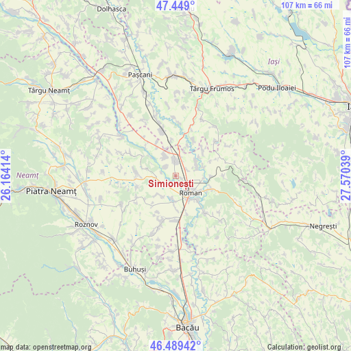
Simionești GPS coordinates[2]
46° 58' 16.896" North, 26° 52' 2.136" East
| Map corner | latitude | longitude |
|---|---|---|
| Upper-left | 47.449°, | 26.16414° |
| Center: | 46.97136°, | 26.86726° |
| Lower-right: | 46.48942°, | 27.57039° |
| Map W x H: | 106.7×106.7 km | = 66.3×66.3mi |
| max Lat: | 48.23793° ⇑21.6% North |
| Simionești: | 46.97136° |
| min Lat: | ⇓78.4% South 43.65638° |
| min Long | Simionești | max Long |
| 20.31667° | 26.86726° | 29.65403° |
| W 80.2%⇐ | ⇒19.8% E |
Elevation
Elevation of Simionești is 201 m = 659 ft, and this is 53.9 m = 177 ft below average elevation for this country.
| Max E: |
1278 m = 4193 ft | 52.1% |
| Avg. | 254.9 m = 836 ft | |
| Simionești | 201 m = 659 ft | |
Min E: |
-2 m = -7 ft | 47.9% |
See also: Romania elevation on elevation.city.
Geographical zone
Simionești is located in North temperate zone (between Tropic of Cancer and the Arctic Circle). Distance of this North polar circle is 2178.4 km =1353.6 mi to North.| Distance of | km | miles | from Simionești |
|---|---|---|---|
| North Pole | 4784.3 | 2972.8 | to North |
| Arctic Circle | 2178.4 | 1353.6 | to North |
| Tropic Cancer | 2616.8 | 1626 | to South |
| Equator | 5222.7 | 3245.2 | to South |


Nearby cities:
15 places around Simionești: (largest is in red/bold)
• Adjudeni
7.8 km =4.8 mi,  52°
52°
• Cordun
2.4 km =1.5 mi,  181°
181°
• Corhana
4.5 km =2.8 mi,  282°
282°
• Dulceşti
7.7 km =4.8 mi,  266°
266°
• Gherăeşti
6.3 km =3.9 mi,  322°
322°
• Gherăeștii Noi
6.3 km =3.9 mi, 322°
• Horia
8.2 km =5.1 mi,  151°
151°
• Miron Costin
7.4 km =4.6 mi,  219°
219°
• Pildești
4.2 km =2.6 mi,  311°
311°
• Roman
7.2 km =4.5 mi,  141°
141°
• Săbăoani
5.2 km =3.2 mi,  345°
345°
• Tețcani
7.3 km =4.5 mi,  344°
344°
• Traian
3.6 km =2.2 mi, 51°
• Trifeşti
7.2 km =4.5 mi,  212°
212°
• Tămăşeni
5.2 km =3.2 mi,  75°
75°
Sources, notices
• [Note1] Compared only with cities in Romania existing in our database
• [Src1] Map data: © OpenStreetMap contributors (CC-BY-SA)
• [Src2] Other city data from geonames.org with taken over terms of usage.
• [Src3] Geographical zone / Annual Mean Temperature by Robert A. Rohde @ Wikipedia
