Gherăeşti geodata
Gherăeşti (Neamţ) is a seat of a second-order administrative division; located in Romania in Europe/Bucharest (GMT+3) time zone. With population of 6,448 people, there are 474 cities with bigger population in this country. Compared to other cities in Romania, 79.3% of cities are located further ↓South; 79% of cities are located further ←West and 50.3% of cities have higher elevation than Gherăeşti. Note1


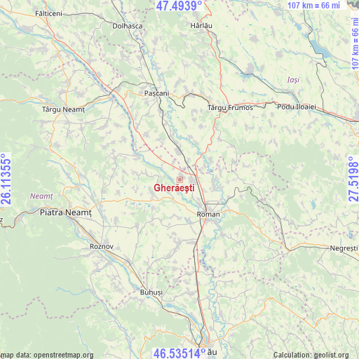
Gherăeşti GPS coordinates[2]
47° 1' 0.012" North, 26° 49' 0.012" East
| Map corner | latitude | longitude |
|---|---|---|
| Upper-left | 47.4939°, | 26.11355° |
| Center: | 47.01667°, | 26.81667° |
| Lower-right: | 46.53514°, | 27.5198° |
| Map W x H: | 106.6×106.6 km | = 66.2×66.2mi |
| max Lat: | 48.23793° ⇑20.7% North |
| Gherăeşti: | 47.01667° |
| min Lat: | ⇓79.3% South 43.65638° |
| min Long | Gherăeşti | max Long |
| 20.31667° | 26.81667° | 29.65403° |
| W 79%⇐ | ⇒21% E |
Elevation
Elevation of Gherăeşti is 210 m = 689 ft, and this is 44.9 m = 147 ft below average elevation for this country.
| Max E: |
1278 m = 4193 ft | 50.3% |
| Avg. | 254.9 m = 836 ft | |
| Gherăeşti | 210 m = 689 ft | |
Min E: |
-2 m = -7 ft | 49.7% |
See also: Romania elevation on elevation.city.
Geographical zone
Gherăeşti is located in North temperate zone (between Tropic of Cancer and the Arctic Circle). Distance of this North polar circle is 2173.4 km =1350.5 mi to North.| Distance of | km | miles | from Gherăeşti |
|---|---|---|---|
| North Pole | 4779.3 | 2969.7 | to North |
| Arctic Circle | 2173.4 | 1350.5 | to North |
| Tropic Cancer | 2621.8 | 1629.1 | to South |
| Equator | 5227.8 | 3248.4 | to South |


Nearby cities:
15 places around Gherăeşti: (largest is in red/bold)
• Barticești
5.5 km =3.4 mi,  340°
340°
• Botești
6.5 km =4 mi,  307°
307°
• Cordun
8.3 km =5.2 mi,  152°
152°
• Corhana
4.1 km =2.5 mi,  187°
187°
• Dulceşti
6.7 km =4.2 mi,  214°
214°
• Gherăeștii Noi
0 km =0 mi,  0°
0°
• Iugani
3.2 km =2 mi,  16°
16°
• Izvoarele
7.1 km =4.4 mi,  66°
66°
• Mirceşti
7.5 km =4.7 mi,  9°
9°
• Pildești
2.3 km =1.4 mi,  163°
163°
• Răchiteni
8.7 km =5.4 mi,  61°
61°
• Simionești
6.3 km =3.9 mi,  142°
142°
• Săbăoani
2.5 km =1.6 mi,  90°
90°
• Tețcani
2.8 km =1.7 mi,  44°
44°
• Traian
7.2 km =4.5 mi,  112°
112°
Sources, notices
• [Note1] Compared only with cities in Romania existing in our database
• [Src1] Map data: © OpenStreetMap contributors (CC-BY-SA)
• [Src2] Other city data from geonames.org with taken over terms of usage.
• [Src3] Geographical zone / Annual Mean Temperature by Robert A. Rohde @ Wikipedia
