Săveni geodata
Săveni (Iaşi) is a populated place; located in Romania in Europe/Bucharest (GMT+3) time zone. With population of 731 people, there are 5393 cities with bigger population in this country. Compared to other cities in Romania, 88.8% of cities are located further ↓South; 87.5% of cities are located further ←West and 68% of cities have higher elevation than Săveni. Note1


Săveni GPS coordinates[2]
47° 23' 58.956" North, 27° 14' 53.16" East
| Map corner | latitude | longitude |
|---|---|---|
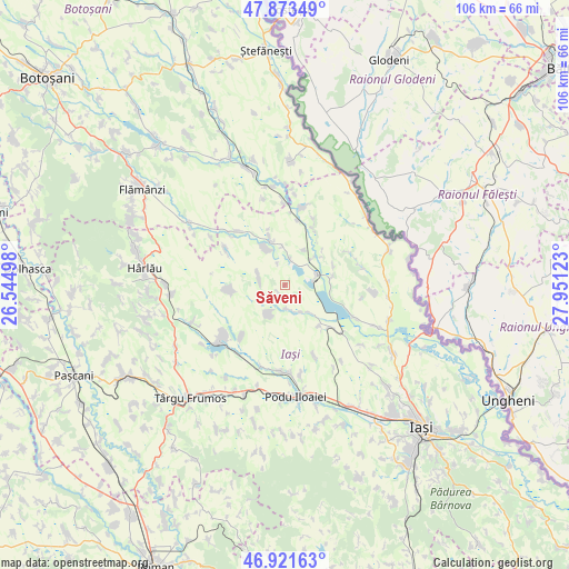
| Upper-left | 47.87349°, | 26.54498° |
| Center: | 47.39971°, | 27.2481° |
| Lower-right: | 46.92163°, | 27.95123° |
| Map W x H: | 105.8×105.8 km | = 65.7×65.7mi |
| max Lat: | 48.23793° ⇑11.2% North |
| Săveni: | 47.39971° |
| min Lat: | ⇓88.8% South 43.65638° |
| min Long | Săveni | max Long |
| 20.31667° | 27.2481° | 29.65403° |
| W 87.5%⇐ | ⇒12.5% E |
Elevation
Elevation of Săveni is 135 m = 443 ft, and this is 119.9 m = 393 ft below average elevation for this country.
| Max E: |
1278 m = 4193 ft | 68% |
| Avg. | 254.9 m = 836 ft | |
| Săveni | 135 m = 443 ft | |
Min E: |
-2 m = -7 ft | 32% |
See also: Romania elevation on elevation.city.
Geographical zone
Săveni is located in North temperate zone (between Tropic of Cancer and the Arctic Circle). Distance of this North polar circle is 2130.8 km =1324 mi to North.| Distance of | km | miles | from Săveni |
|---|---|---|---|
| North Pole | 4736.7 | 2943.2 | to North |
| Arctic Circle | 2130.8 | 1324 | to North |
| Tropic Cancer | 2664.4 | 1655.6 | to South |
| Equator | 5270.4 | 3274.9 | to South |


Nearby cities:
15 places around Săveni: (largest is in red/bold)
• Alexandru cel Bun
7.4 km =4.6 mi,  28°
28°
• Arama
10.1 km =6.3 mi,  269°
269°
• Borșa
9 km =5.6 mi,  78°
78°
• Bulbucani
4.5 km =2.8 mi,  178°
178°
• Chișcăreni
8.7 km =5.4 mi,  333°
333°
• Focuri
6 km =3.7 mi,  203°
203°
• Forăști
5.7 km =3.5 mi,  151°
151°
• Fântânele
5.4 km =3.4 mi,  288°
288°
• Gropniţa
5.5 km =3.4 mi, 178°
• Hălceni
4.8 km =3 mi,  13°
13°
• Iazu Nou
9.7 km =6 mi,  342°
342°
• Potângeni
10.2 km =6.3 mi,  139°
139°
• Spineni
11.3 km =7 mi, 28°
• Vlădeni
6.7 km =4.2 mi,  73°
73°
• Şipote
7.8 km =4.8 mi, 342°
Sources, notices
• [Note1] Compared only with cities in Romania existing in our database
• [Src1] Map data: © OpenStreetMap contributors (CC-BY-SA)
• [Src2] Other city data from geonames.org with taken over terms of usage.
• [Src3] Geographical zone / Annual Mean Temperature by Robert A. Rohde @ Wikipedia
