Gropniţa geodata
Gropniţa (Iaşi) is a seat of a second-order administrative division; located in Romania in Europe/Bucharest (GMT+3) time zone. With population of 3,414 people, there are 1483 cities with bigger population in this country. Compared to other cities in Romania, 87.6% of cities are located further ↓South; 87.5% of cities are located further ←West and 77% of cities have higher elevation than Gropniţa. Note1


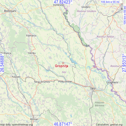
Gropniţa GPS coordinates[2]
47° 21' 0" North, 27° 15' 0" East
| Map corner | latitude | longitude |
|---|---|---|
| Upper-left | 47.82423°, | 26.54688° |
| Center: | 47.35°, | 27.25° |
| Lower-right: | 46.87147°, | 27.95313° |
| Map W x H: | 105.9×105.9 km | = 65.8×65.8mi |
| max Lat: | 48.23793° ⇑12.4% North |
| Gropniţa: | 47.35° |
| min Lat: | ⇓87.6% South 43.65638° |
| min Long | Gropniţa | max Long |
| 20.31667° | 27.25° | 29.65403° |
| W 87.5%⇐ | ⇒12.5% E |
Elevation
Elevation of Gropniţa is 104 m = 341 ft, and this is 150.9 m = 495 ft below average elevation for this country.
| Max E: |
1278 m = 4193 ft | 77% |
| Avg. | 254.9 m = 836 ft | |
| Gropniţa | 104 m = 341 ft | |
Min E: |
-2 m = -7 ft | 23% |
See also: Romania elevation on elevation.city.
Geographical zone
Gropniţa is located in North temperate zone (between Tropic of Cancer and the Arctic Circle). Distance of this North polar circle is 2136.3 km =1327.4 mi to North.| Distance of | km | miles | from Gropniţa |
|---|---|---|---|
| North Pole | 4742.2 | 2946.7 | to North |
| Arctic Circle | 2136.3 | 1327.4 | to North |
| Tropic Cancer | 2658.9 | 1652.2 | to South |
| Equator | 5264.8 | 3271.4 | to South |


Nearby cities:
15 places around Gropniţa: (largest is in red/bold)
• Borșa
11.3 km =7 mi,  49°
49°
• Bulbucani
1 km =0.6 mi,  357°
357°
• Erbiceni
9.4 km =5.8 mi,  187°
187°
• Focuri
2.5 km =1.6 mi,  270°
270°
• Forăști
2.6 km =1.6 mi,  78°
78°
• Fântânele
8.9 km =5.5 mi,  324°
324°
• Hălceni
10.3 km =6.4 mi,  5°
5°
• Larga-Jijia
10.8 km =6.7 mi,  107°
107°
• Movileni
8.4 km =5.2 mi,  116°
116°
• Munteni
9.3 km =5.8 mi,  245°
245°
• Potângeni
6.9 km =4.3 mi, 108°
• Româneşti
9 km =5.6 mi,  145°
145°
• Săveni
5.5 km =3.4 mi, 358°
• Totoești
11.4 km =7.1 mi,  165°
165°
• Vlădeni
9.7 km =6 mi,  40°
40°
Sources, notices
• [Note1] Compared only with cities in Romania existing in our database
• [Src1] Map data: © OpenStreetMap contributors (CC-BY-SA)
• [Src2] Other city data from geonames.org with taken over terms of usage.
• [Src3] Geographical zone / Annual Mean Temperature by Robert A. Rohde @ Wikipedia
