Satu Mare geodata
Satu Mare (Harghita) is a seat of a second-order administrative division; located in Romania in Europe/Bucharest (GMT+3) time zone. With population of 2,017 people, there are 2580 cities with bigger population in this country. Compared to other cities in Romania, 63.2% of cities are located further ↓South; 52.5% of cities are located further ←West and 91.4% of cities have lower elevation than Satu Mare. Note1


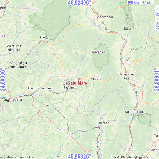
Satu Mare GPS coordinates[2]
46° 20' 26.952" North, 25° 23' 1.608" East
| Map corner | latitude | longitude |
|---|---|---|
| Upper-left | 46.82408°, | 24.68066° |
| Center: | 46.34082°, | 25.38378° |
| Lower-right: | 45.85325°, | 26.08691° |
| Map W x H: | 107.9×107.9 km | = 67×67mi |
| max Lat: | 48.23793° ⇑36.8% North |
| Satu Mare: | 46.34082° |
| min Lat: | ⇓63.2% South 43.65638° |
| min Long | Satu Mare | max Long |
| 20.31667° | 25.38378° | 29.65403° |
| W 52.5%⇐ | ⇒47.5% E |
Elevation
Elevation of Satu Mare is 538 m = 1765 ft, and this is 283.1 m = 929 ft above average elevation for this country.
| Max E: |
1278 m = 4193 ft | 8.6% |
| Satu Mare | 538 m 1765 ft | |
| Avg. | 254.9 m = 836 ft | |
Min E: |
-2 m = -7 ft | 91.4% |
See also: Romania elevation on elevation.city.
Geographical zone
Satu Mare is located in North temperate zone (between Tropic of Cancer and the Arctic Circle). Distance of this North polar circle is 2248.6 km =1397.2 mi to North.| Distance of | km | miles | from Satu Mare |
|---|---|---|---|
| North Pole | 4854.4 | 3016.4 | to North |
| Arctic Circle | 2248.6 | 1397.2 | to North |
| Tropic Cancer | 2546.7 | 1582.4 | to South |
| Equator | 5152.6 | 3201.7 | to South |


Nearby cities:
15 places around Satu Mare: (largest is in red/bold)
• Bisericani
11.2 km =7 mi,  285°
285°
• Brădeşti
2.8 km =1.7 mi, 291°
• Căpâlniţa
10.6 km =6.6 mi,  74°
74°
• Dealu
9.2 km =5.7 mi,  315°
315°
• Feliceni
12.2 km =7.6 mi,  227°
227°
• Lueta
11.2 km =7 mi,  137°
137°
• Mereşti
13 km =8.1 mi,  156°
156°
• Morăreni
12.7 km =7.9 mi,  279°
279°
• Mărtiniş
12 km =7.5 mi,  180°
180°
• Odorheiu Secuiesc
7.9 km =4.9 mi, 234°
• Sub Cetate
11.6 km =7.2 mi,  2°
2°
• Sâncrai
5.9 km =3.7 mi,  299°
299°
• Tăureni
13.2 km =8.2 mi, 231°
• Vlăhiţa
10.3 km =6.4 mi,  84°
84°
• Zetea
4.9 km =3 mi,  344°
344°
Sources, notices
• [Note1] Compared only with cities in Romania existing in our database
• [Src1] Map data: © OpenStreetMap contributors (CC-BY-SA)
• [Src2] Other city data from geonames.org with taken over terms of usage.
• [Src3] Geographical zone / Annual Mean Temperature by Robert A. Rohde @ Wikipedia
