Brădeşti geodata
Brădeşti (Harghita) is a seat of a second-order administrative division; located in Romania in Europe/Bucharest (GMT+3) time zone. With population of 3,510 people, there are 1419 cities with bigger population in this country. Compared to other cities in Romania, 63.3% of cities are located further ↓South; 52% of cities are located further ←West and 91.5% of cities have lower elevation than Brădeşti. Note1


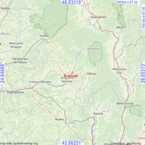
Brădeşti GPS coordinates[2]
46° 21' 0" North, 25° 21' 0" East
| Map corner | latitude | longitude |
|---|---|---|
| Upper-left | 46.83318°, | 24.64688° |
| Center: | 46.35°, | 25.35° |
| Lower-right: | 45.86251°, | 26.05313° |
| Map W x H: | 107.9×107.9 km | = 67×67mi |
| max Lat: | 48.23793° ⇑36.7% North |
| Brădeşti: | 46.35° |
| min Lat: | ⇓63.3% South 43.65638° |
| min Long | Brădeşti | max Long |
| 20.31667° | 25.35° | 29.65403° |
| W 52%⇐ | ⇒48% E |
Elevation
Elevation of Brădeşti is 539 m = 1768 ft, and this is 284.1 m = 932 ft above average elevation for this country.
| Max E: |
1278 m = 4193 ft | 8.5% |
| Brădeşti | 539 m 1768 ft | |
| Avg. | 254.9 m = 836 ft | |
Min E: |
-2 m = -7 ft | 91.5% |
See also: Romania elevation on elevation.city.
Geographical zone
Brădeşti is located in North temperate zone (between Tropic of Cancer and the Arctic Circle). Distance of this North polar circle is 2247.5 km =1396.5 mi to North.| Distance of | km | miles | from Brădeşti |
|---|---|---|---|
| North Pole | 4853.4 | 3015.8 | to North |
| Arctic Circle | 2247.5 | 1396.5 | to North |
| Tropic Cancer | 2547.7 | 1583.1 | to South |
| Equator | 5153.6 | 3202.3 | to South |


Nearby cities:
15 places around Brădeşti: (largest is in red/bold)
• Bisericani
8.4 km =5.2 mi,  284°
284°
• Căpâlniţa
12.9 km =8 mi,  81°
81°
• Dealu
6.8 km =4.2 mi,  325°
325°
• Feliceni
11.3 km =7 mi,  214°
214°
• Lueta
13.8 km =8.6 mi,  132°
132°
• Lupeni
10.9 km =6.8 mi,  289°
289°
• Morăreni
10 km =6.2 mi, 275°
• Mărtiniş
13.2 km =8.2 mi,  168°
168°
• Odorheiu Secuiesc
6.8 km =4.2 mi, 214°
• Satu Mare
2.8 km =1.7 mi,  111°
111°
• Sub Cetate
11 km =6.8 mi,  15°
15°
• Sâncrai
3.2 km =2 mi,  305°
305°
• Tăureni
12 km =7.5 mi,  219°
219°
• Vlăhiţa
12.8 km =8 mi,  90°
90°
• Zetea
3.9 km =2.4 mi, 19°
Sources, notices
• [Note1] Compared only with cities in Romania existing in our database
• [Src1] Map data: © OpenStreetMap contributors (CC-BY-SA)
• [Src2] Other city data from geonames.org with taken over terms of usage.
• [Src3] Geographical zone / Annual Mean Temperature by Robert A. Rohde @ Wikipedia
