Sălăjeni geodata
Sălăjeni (Sălaj) is a populated place; located in Romania in Europe/Bucharest (GMT+3) time zone. With population of 612 people, there are 6124 cities with bigger population in this country. Compared to other cities in Romania, 87.1% of cities are located further ↓South; 85.8% of cities are located further →East and 52.1% of cities have higher elevation than Sălăjeni. Note1


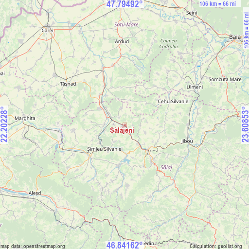
Sălăjeni GPS coordinates[2]
47° 19' 13.512" North, 22° 54' 19.44" East
| Map corner | latitude | longitude |
|---|---|---|
| Upper-left | 47.79492°, | 22.20228° |
| Center: | 47.32042°, | 22.9054° |
| Lower-right: | 46.84162°, | 23.60853° |
| Map W x H: | 106×106 km | = 65.9×65.9mi |
| max Lat: | 48.23793° ⇑12.9% North |
| Sălăjeni: | 47.32042° |
| min Lat: | ⇓87.1% South 43.65638° |
| min Long | Sălăjeni | max Long |
| 20.31667° | 22.9054° | 29.65403° |
| W 14.2%⇐ | ⇒85.8% E |
Elevation
Elevation of Sălăjeni is 201 m = 659 ft, and this is 53.9 m = 177 ft below average elevation for this country.
| Max E: |
1278 m = 4193 ft | 52.1% |
| Avg. | 254.9 m = 836 ft | |
| Sălăjeni | 201 m = 659 ft | |
Min E: |
-2 m = -7 ft | 47.9% |
See also: Romania elevation on elevation.city.
Geographical zone
Sălăjeni is located in North temperate zone (between Tropic of Cancer and the Arctic Circle). Distance of this North polar circle is 2139.6 km =1329.5 mi to North.| Distance of | km | miles | from Sălăjeni |
|---|---|---|---|
| North Pole | 4745.5 | 2948.7 | to North |
| Arctic Circle | 2139.6 | 1329.5 | to North |
| Tropic Cancer | 2655.6 | 1650.1 | to South |
| Equator | 5261.5 | 3269.3 | to South |


Nearby cities:
15 places around Sălăjeni: (largest is in red/bold)
• Archid
8.6 km =5.3 mi,  71°
71°
• Bocşa
3 km =1.9 mi,  167°
167°
• Bădăcin
8.1 km =5 mi,  208°
208°
• Chieşd
7.2 km =4.5 mi,  346°
346°
• Coşeiu
5.9 km =3.7 mi,  94°
94°
• Dioșod
9.3 km =5.8 mi,  109°
109°
• Giurtelecu Șimleului
8.7 km =5.4 mi,  252°
252°
• Guruslău
7.5 km =4.7 mi,  128°
128°
• Ilișua
5.6 km =3.5 mi,  242°
242°
• Lompirt
4.5 km =2.8 mi,  273°
273°
• Măerişte
8 km =5 mi, 266°
• Ser
7.8 km =4.8 mi,  34°
34°
• Sighetu Silvaniei
3.9 km =2.4 mi,  325°
325°
• Şamşud
4.7 km =2.9 mi,  45°
45°
• Şărmăşag
6.3 km =3.9 mi,  301°
301°
Sources, notices
• [Note1] Compared only with cities in Romania existing in our database
• [Src1] Map data: © OpenStreetMap contributors (CC-BY-SA)
• [Src2] Other city data from geonames.org with taken over terms of usage.
• [Src3] Geographical zone / Annual Mean Temperature by Robert A. Rohde @ Wikipedia
