Pogonele geodata
Pogonele (Buzău) is a populated place; located in Romania in Europe/Bucharest (GMT+3) time zone. With population of 1,518 people, there are 3142 cities with bigger population in this country. Compared to other cities in Romania, 66% of cities are located further ↑North; 80.1% of cities are located further ←West and 84.2% of cities have higher elevation than Pogonele. Note1


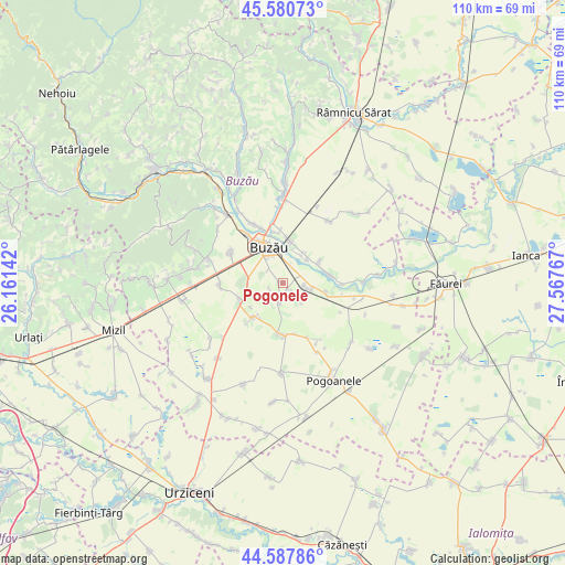
Pogonele GPS coordinates[2]
45° 5' 11.22" North, 26° 51' 52.344" East
| Map corner | latitude | longitude |
|---|---|---|
| Upper-left | 45.58073°, | 26.16142° |
| Center: | 45.08645°, | 26.86454° |
| Lower-right: | 44.58786°, | 27.56767° |
| Map W x H: | 110.4×110.4 km | = 68.6×68.6mi |
| max Lat: | 48.23793° ⇑66% North |
| Pogonele: | 45.08645° |
| min Lat: | ⇓34% South 43.65638° |
| min Long | Pogonele | max Long |
| 20.31667° | 26.86454° | 29.65403° |
| W 80.1%⇐ | ⇒19.9% E |
Elevation
Elevation of Pogonele is 81 m = 266 ft, and this is 173.9 m = 571 ft below average elevation for this country.
| Max E: |
1278 m = 4193 ft | 84.2% |
| Avg. | 254.9 m = 836 ft | |
| Pogonele | 81 m = 266 ft | |
Min E: |
-2 m = -7 ft | 15.8% |
See also: Romania elevation on elevation.city.
Geographical zone
Pogonele is located in North temperate zone (between Tropic of Cancer and the Arctic Circle). Distance of this North polar circle is 2388 km =1483.8 mi to North.| Distance of | km | miles | from Pogonele |
|---|---|---|---|
| North Pole | 4993.9 | 3103.1 | to North |
| Arctic Circle | 2388 | 1483.8 | to North |
| Tropic Cancer | 2407.2 | 1495.8 | to South |
| Equator | 5013.1 | 3115 | to South |


Nearby cities:
15 places around Pogonele: (largest is in red/bold)
• Bentu
8.9 km =5.5 mi,  103°
103°
• Budișteni
7.8 km =4.8 mi,  232°
232°
• Buzău
7.5 km =4.7 mi,  340°
340°
• Costeşti
8.7 km =5.4 mi,  242°
242°
• Dâmbroca
8.2 km =5.1 mi,  60°
60°
• Gherăseni
8.9 km =5.5 mi,  220°
220°
• Gălbinaşi
4.1 km =2.5 mi,  94°
94°
• Maxenu
3.9 km =2.4 mi,  190°
190°
• Pietrosu
8.9 km =5.5 mi,  250°
250°
• Scurtești
6.5 km =4 mi,  28°
28°
• Spătaru
6.7 km =4.2 mi,  268°
268°
• Stăncești
6.4 km =4 mi,  45°
45°
• Sudiți
8.3 km =5.2 mi,  211°
211°
• Tăbărăști
4.4 km =2.7 mi, 100°
• Ţinteşti
2.2 km =1.4 mi,  175°
175°
Sources, notices
• [Note1] Compared only with cities in Romania existing in our database
• [Src1] Map data: © OpenStreetMap contributors (CC-BY-SA)
• [Src2] Other city data from geonames.org with taken over terms of usage.
• [Src3] Geographical zone / Annual Mean Temperature by Robert A. Rohde @ Wikipedia
