Pocola geodata
Pocola (Bihor) is a seat of a second-order administrative division; located in Romania in Europe/Bucharest (GMT+3) time zone. With population of 1,646 people, there are 2986 cities with bigger population in this country. Compared to other cities in Romania, 71.1% of cities are located further ↓South; 91.9% of cities are located further →East and 60.2% of cities have higher elevation than Pocola. Note1


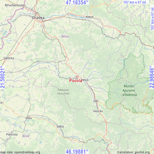
Pocola GPS coordinates[2]
46° 40' 59.988" North, 22° 16' 59.988" East
| Map corner | latitude | longitude |
|---|---|---|
| Upper-left | 47.16354°, | 21.58021° |
| Center: | 46.68333°, | 22.28333° |
| Lower-right: | 46.19881°, | 22.98646° |
| Map W x H: | 107.3×107.3 km | = 66.7×66.7mi |
| max Lat: | 48.23793° ⇑28.9% North |
| Pocola: | 46.68333° |
| min Lat: | ⇓71.1% South 43.65638° |
| min Long | Pocola | max Long |
| 20.31667° | 22.28333° | 29.65403° |
| W 8.1%⇐ | ⇒91.9% E |
Elevation
Elevation of Pocola is 165 m = 541 ft, and this is 89.9 m = 295 ft below average elevation for this country.
| Max E: |
1278 m = 4193 ft | 60.2% |
| Avg. | 254.9 m = 836 ft | |
| Pocola | 165 m = 541 ft | |
Min E: |
-2 m = -7 ft | 39.8% |
See also: Romania elevation on elevation.city.
Geographical zone
Pocola is located in North temperate zone (between Tropic of Cancer and the Arctic Circle). Distance of this North polar circle is 2210.5 km =1373.5 mi to North.| Distance of | km | miles | from Pocola |
|---|---|---|---|
| North Pole | 4816.4 | 2992.8 | to North |
| Arctic Circle | 2210.5 | 1373.5 | to North |
| Tropic Cancer | 2584.8 | 1606.1 | to South |
| Equator | 5190.7 | 3225.4 | to South |


Nearby cities:
15 places around Pocola: (largest is in red/bold)
• Beiuş
5.4 km =3.4 mi,  110°
110°
• Drăgoteni
5.8 km =3.6 mi,  19°
19°
• Feneriș
3.2 km =2 mi,  6°
6°
• Finiş
6.1 km =3.8 mi,  155°
155°
• Forău
7 km =4.3 mi,  295°
295°
• Ioaniș
1.5 km =0.9 mi,  202°
202°
• Nimăiești
8.3 km =5.2 mi,  90°
90°
• Prisaca
5.2 km =3.2 mi,  306°
306°
• Remetea
7.5 km =4.7 mi,  42°
42°
• Răbăgani
8.3 km =5.2 mi,  332°
332°
• Săucani
5.8 km =3.6 mi,  346°
346°
• Tărcaia
8.4 km =5.2 mi,  131°
131°
• Uileacu de Beiuș
4.7 km =2.9 mi,  272°
272°
• Urviș de Beiuș
9.6 km =6 mi,  276°
276°
• Șuncuiș
1.6 km =1 mi,  232°
232°
Sources, notices
• [Note1] Compared only with cities in Romania existing in our database
• [Src1] Map data: © OpenStreetMap contributors (CC-BY-SA)
• [Src2] Other city data from geonames.org with taken over terms of usage.
• [Src3] Geographical zone / Annual Mean Temperature by Robert A. Rohde @ Wikipedia
