Plopeni geodata
Plopeni (Prahova) is a seat of a second-order administrative division; located in Romania in Europe/Bucharest (GMT+3) time zone. With population of 7,718 people, there are 337 cities with bigger population in this country. Compared to other cities in Romania, 67.8% of cities are located further ↑North; 62% of cities are located further ←West and 58.3% of cities have lower elevation than Plopeni. Note1


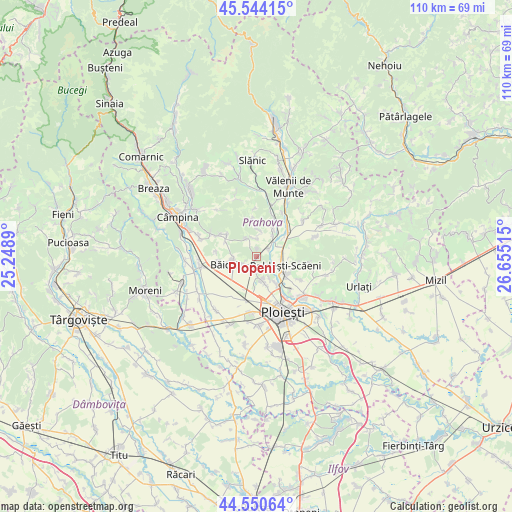
Plopeni GPS coordinates[2]
45° 2' 58.38" North, 25° 57' 7.272" East
| Map corner | latitude | longitude |
|---|---|---|
| Upper-left | 45.54415°, | 25.2489° |
| Center: | 45.04955°, | 25.95202° |
| Lower-right: | 44.55064°, | 26.65515° |
| Map W x H: | 110.5×110.5 km | = 68.7×68.7mi |
| max Lat: | 48.23793° ⇑67.8% North |
| Plopeni: | 45.04955° |
| min Lat: | ⇓32.2% South 43.65638° |
| min Long | Plopeni | max Long |
| 20.31667° | 25.95202° | 29.65403° |
| W 62%⇐ | ⇒38% E |
Elevation
Elevation of Plopeni is 254 m = 833 ft, and this is 0.90000000000001 m = 3 ft below average elevation for this country.
| Max E: |
1278 m = 4193 ft | 41.7% |
| Avg. | 254.9 m = 836 ft | |
| Plopeni | 254 m = 833 ft | |
Min E: |
-2 m = -7 ft | 58.3% |
See also: Romania elevation on elevation.city.
Geographical zone
Plopeni is located in North temperate zone (between Tropic of Cancer and the Arctic Circle). Distance of this North polar circle is 2392.1 km =1486.4 mi to North.| Distance of | km | miles | from Plopeni |
|---|---|---|---|
| North Pole | 4998 | 3105.6 | to North |
| Arctic Circle | 2392.1 | 1486.4 | to North |
| Tropic Cancer | 2403.1 | 1493.2 | to South |
| Equator | 5009 | 3112.4 | to South |


Nearby cities:
15 places around Plopeni: (largest is in red/bold)
• Cocorăștii Mislii
4.6 km =2.9 mi,  329°
329°
• Cocoșești
5.3 km =3.3 mi,  151°
151°
• Dumbrăveşti
5.3 km =3.3 mi,  45°
45°
• Dâmbu
5 km =3.1 mi,  264°
264°
• Goruna
4.2 km =2.6 mi,  349°
349°
• Găgeni
3.1 km =1.9 mi,  188°
188°
• Iazu
6.4 km =4 mi,  56°
56°
• Liliești
5.5 km =3.4 mi,  252°
252°
• Lipăneşti
5.1 km =3.2 mi,  89°
89°
• Plopeni
2.9 km =1.8 mi, 52°
• Păuleşti
6 km =3.7 mi,  155°
155°
• Zamfira
4.9 km =3 mi, 64°
• Șipotu
5.2 km =3.2 mi,  100°
100°
• Țintea
4.1 km =2.5 mi, 245°
• Țipărești
4 km =2.5 mi,  4°
4°
Sources, notices
• [Note1] Compared only with cities in Romania existing in our database
• [Src1] Map data: © OpenStreetMap contributors (CC-BY-SA)
• [Src2] Other city data from geonames.org with taken over terms of usage.
• [Src3] Geographical zone / Annual Mean Temperature by Robert A. Rohde @ Wikipedia
