Platonești geodata
Platonești (Ialomiţa) is a seat of a second-order administrative division; located in Romania in Europe/Bucharest (GMT+3) time zone. With population of 995 people, there are 4310 cities with bigger population in this country. Compared to other cities in Romania, 82.6% of cities are located further ↑North; 93.1% of cities are located further ←West and 98.6% of cities have higher elevation than Platonești. Note1


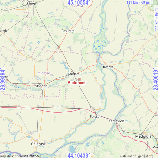
Platonești GPS coordinates[2]
44° 36' 25.632" North, 27° 41' 49.416" East
| Map corner | latitude | longitude |
|---|---|---|
| Upper-left | 45.10554°, | 26.99394° |
| Center: | 44.60712°, | 27.69706° |
| Lower-right: | 44.10438°, | 28.40019° |
| Map W x H: | 111.3×111.3 km | = 69.2×69.2mi |
| max Lat: | 48.23793° ⇑82.6% North |
| Platonești: | 44.60712° |
| min Lat: | ⇓17.4% South 43.65638° |
| min Long | Platonești | max Long |
| 20.31667° | 27.69706° | 29.65403° |
| W 93.1%⇐ | ⇒6.9% E |
Elevation
Elevation of Platonești is 14 m = 46 ft, and this is 240.9 m = 790 ft below average elevation for this country.
| Max E: |
1278 m = 4193 ft | 98.6% |
| Avg. | 254.9 m = 836 ft | |
| Platonești | 14 m = 46 ft | |
Min E: |
-2 m = -7 ft | 1.4% |
See also: Romania elevation on elevation.city.
Geographical zone
Platonești is located in North temperate zone (between Tropic of Cancer and the Arctic Circle). Distance of this Northern Tropic circle is 2353.9 km =1462.6 mi to South.| Distance of | km | miles | from Platonești |
|---|---|---|---|
| North Pole | 5047.2 | 3136.2 | to North |
| Arctic Circle | 2441.3 | 1517 | to North |
| Tropic Cancer | 2353.9 | 1462.6 | to South |
| Equator | 4959.8 | 3081.9 | to South |


Nearby cities:
15 places around Platonești: (largest is in red/bold)
• Bucu
16.1 km =10 mi,  269°
269°
• Frățilești
7.4 km =4.6 mi,  276°
276°
• Gura Ialomiței
12.9 km =8 mi,  20°
20°
• Luciu
15.8 km =9.8 mi,  8°
8°
• Lăcusteni
1.7 km =1.1 mi, 270°
• Mihail Kogălniceanu
8.9 km =5.5 mi, 18°
• Movila
6.4 km =4 mi,  177°
177°
• Mărculești
15 km =9.3 mi,  252°
252°
• Ograda
10.1 km =6.3 mi, 274°
• Progresu
13.9 km =8.6 mi,  102°
102°
• Sudiţi
8.1 km =5 mi, 251°
• Săveni
3.8 km =2.4 mi,  258°
258°
• Valea Ciorii
16 km =9.9 mi,  319°
319°
• Vlădeni
14.8 km =9.2 mi,  85°
85°
• Ţăndărei
5.3 km =3.3 mi,  333°
333°
Sources, notices
• [Note1] Compared only with cities in Romania existing in our database
• [Src1] Map data: © OpenStreetMap contributors (CC-BY-SA)
• [Src2] Other city data from geonames.org with taken over terms of usage.
• [Src3] Geographical zone / Annual Mean Temperature by Robert A. Rohde @ Wikipedia
