Săveni geodata
Săveni (Ialomiţa) is a seat of a second-order administrative division; located in Romania in Europe/Bucharest (GMT+3) time zone. With population of 5,579 people, there are 628 cities with bigger population in this country. Compared to other cities in Romania, 82.9% of cities are located further ↑North; 92.7% of cities are located further ←West and 94.7% of cities have higher elevation than Săveni. Note1


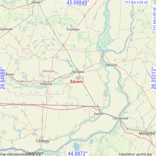
Săveni GPS coordinates[2]
44° 36' 0" North, 27° 39' 0" East
| Map corner | latitude | longitude |
|---|---|---|
| Upper-left | 45.09849°, | 26.94688° |
| Center: | 44.6°, | 27.65° |
| Lower-right: | 44.0972°, | 28.35313° |
| Map W x H: | 111.3×111.3 km | = 69.2×69.2mi |
| max Lat: | 48.23793° ⇑82.9% North |
| Săveni: | 44.6° |
| min Lat: | ⇓17.1% South 43.65638° |
| min Long | Săveni | max Long |
| 20.31667° | 27.65° | 29.65403° |
| W 92.7%⇐ | ⇒7.3% E |
Elevation
Elevation of Săveni is 36 m = 118 ft, and this is 218.9 m = 718 ft below average elevation for this country.
| Max E: |
1278 m = 4193 ft | 94.7% |
| Avg. | 254.9 m = 836 ft | |
| Săveni | 36 m = 118 ft | |
Min E: |
-2 m = -7 ft | 5.3% |
See also: Romania elevation on elevation.city.
Geographical zone
Săveni is located in North temperate zone (between Tropic of Cancer and the Arctic Circle). Distance of this Northern Tropic circle is 2353.1 km =1462.1 mi to South.| Distance of | km | miles | from Săveni |
|---|---|---|---|
| North Pole | 5048 | 3136.7 | to North |
| Arctic Circle | 2442.1 | 1517.5 | to North |
| Tropic Cancer | 2353.1 | 1462.1 | to South |
| Equator | 4959.1 | 3081.4 | to South |


Nearby cities:
15 places around Săveni: (largest is in red/bold)
• Bucu
12.4 km =7.7 mi,  272°
272°
• Frățilești
4 km =2.5 mi,  294°
294°
• Gheorghe Lazăr
16.3 km =10.1 mi,  283°
283°
• Gura Ialomiței
15.3 km =9.5 mi,  32°
32°
• Luciu
17.5 km =10.9 mi,  20°
20°
• Lăcusteni
2.2 km =1.4 mi,  68°
68°
• Mihail Kogălniceanu
11.4 km =7.1 mi,  35°
35°
• Movila
6.8 km =4.2 mi,  144°
144°
• Mărculești
11.3 km =7 mi,  250°
250°
• Ograda
6.5 km =4 mi, 284°
• Platonești
3.8 km =2.4 mi,  78°
78°
• Progresu
17.5 km =10.9 mi,  97°
97°
• Sudiţi
4.4 km =2.7 mi,  244°
244°
• Valea Ciorii
14.6 km =9.1 mi,  333°
333°
• Ţăndărei
5.7 km =3.5 mi,  13°
13°
Sources, notices
• [Note1] Compared only with cities in Romania existing in our database
• [Src1] Map data: © OpenStreetMap contributors (CC-BY-SA)
• [Src2] Other city data from geonames.org with taken over terms of usage.
• [Src3] Geographical zone / Annual Mean Temperature by Robert A. Rohde @ Wikipedia
