Pitulușa geodata
Pitulușa (Vrancea) is a populated place; located in Romania in Europe/Bucharest (GMT+3) time zone. With population of 727 people, there are 5418 cities with bigger population in this country. Compared to other cities in Romania, 50.4% of cities are located further ↑North; 83.1% of cities are located further ←West and 56.8% of cities have higher elevation than Pitulușa. Note1


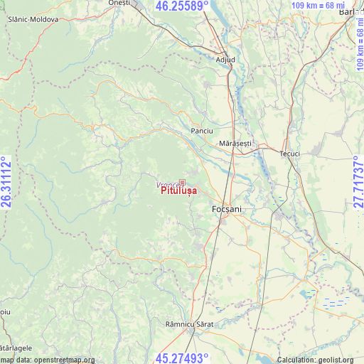
Pitulușa GPS coordinates[2]
45° 46' 3.252" North, 27° 0' 51.264" East
| Map corner | latitude | longitude |
|---|---|---|
| Upper-left | 46.25589°, | 26.31112° |
| Center: | 45.76757°, | 27.01424° |
| Lower-right: | 45.27493°, | 27.71737° |
| Map W x H: | 109.1×109.1 km | = 67.8×67.8mi |
| max Lat: | 48.23793° ⇑50.4% North |
| Pitulușa: | 45.76757° |
| min Lat: | ⇓49.6% South 43.65638° |
| min Long | Pitulușa | max Long |
| 20.31667° | 27.01424° | 29.65403° |
| W 83.1%⇐ | ⇒16.9% E |
Elevation
Elevation of Pitulușa is 179 m = 587 ft, and this is 75.9 m = 249 ft below average elevation for this country.
| Max E: |
1278 m = 4193 ft | 56.8% |
| Avg. | 254.9 m = 836 ft | |
| Pitulușa | 179 m = 587 ft | |
Min E: |
-2 m = -7 ft | 43.2% |
See also: Romania elevation on elevation.city.
Geographical zone
Pitulușa is located in North temperate zone (between Tropic of Cancer and the Arctic Circle). Distance of this North polar circle is 2312.3 km =1436.8 mi to North.| Distance of | km | miles | from Pitulușa |
|---|---|---|---|
| North Pole | 4918.2 | 3056 | to North |
| Arctic Circle | 2312.3 | 1436.8 | to North |
| Tropic Cancer | 2483 | 1542.9 | to South |
| Equator | 5088.9 | 3162.1 | to South |


Nearby cities:
15 places around Pitulușa: (largest is in red/bold)
• Boloteşti
8.4 km =5.2 mi,  29°
29°
• Broşteni
2.5 km =1.6 mi,  142°
142°
• Câmpineanca
10.8 km =6.7 mi,  125°
125°
• Dălhăuți
8.8 km =5.5 mi,  162°
162°
• Faraoanele
6.6 km =4.1 mi, 156°
• Găgești
10.3 km =6.4 mi,  17°
17°
• Jariştea
4.4 km =2.7 mi,  66°
66°
• Mera
5 km =3.1 mi,  268°
268°
• Odobeşti
2.8 km =1.7 mi,  92°
92°
• Putna
9.3 km =5.8 mi,  45°
45°
• Pădureni
3.3 km =2.1 mi, 29°
• Unirea
7.8 km =4.8 mi,  112°
112°
• Vulcăneasa
8.1 km =5 mi, 274°
• Vârteşcoiu
6.6 km =4.1 mi, 125°
• Vărsătura
3.3 km =2.1 mi,  44°
44°
Sources, notices
• [Note1] Compared only with cities in Romania existing in our database
• [Src1] Map data: © OpenStreetMap contributors (CC-BY-SA)
• [Src2] Other city data from geonames.org with taken over terms of usage.
• [Src3] Geographical zone / Annual Mean Temperature by Robert A. Rohde @ Wikipedia
